Bhalwal geodata
Bhalwal (Punjab) is a populated place; located in Pakistan in Asia/Karachi (GMT+5) time zone. With population of 74,744 people, there are 88 cities with bigger population in this country. Compared to other cities in Pakistan, 70.4% of cities are located further ↓South; 70.2% of cities are located further ←West and 57.3% of cities have lower elevation than Bhalwal. Note1


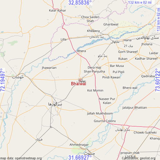
Bhalwal GPS coordinates[2]
32° 15' 56.736" North, 72° 53' 53.124" East
| Map corner | latitude | longitude |
|---|---|---|
| Upper-left | 32.85836°, | 72.19497° |
| Center: | 32.26576°, | 72.89809° |
| Lower-right: | 31.66927°, | 73.60122° |
| Map W x H: | 132.2×132.2 km | = 82.1×82.1mi |
| max Lat: | 36.32162° ⇑29.6% North |
| Bhalwal: | 32.26576° |
| min Lat: | ⇓70.4% South 24.14422° |
| min Long | Bhalwal | max Long |
| 61.74573° | 72.89809° | 75.63372° |
| W 70.2%⇐ | ⇒29.8% E |
Elevation
Elevation of Bhalwal is 196 m = 643 ft, and this is 149 m = 489 ft below average elevation for this country.
| Max E: |
2732 m = 8963 ft | 42.7% |
| Avg. | 345 m = 1132 ft | |
| Bhalwal | 196 m = 643 ft | |
Min E: |
3 m = 10 ft | 57.3% |
See also: Bhalwal elevation on elevation.city.
Geographical zone
Bhalwal is located in North temperate zone (between Tropic of Cancer and the Arctic Circle). Distance of this Northern Tropic circle is 981.7 km =610 mi to South.| Distance of | km | miles | from Bhalwal |
|---|---|---|---|
| North Pole | 6419.4 | 3988.8 | to North |
| Arctic Circle | 3813.6 | 2369.7 | to North |
| Tropic Cancer | 981.7 | 610 | to South |
| Equator | 3587.6 | 2229.2 | to South |


Nearby cities:
15 places around Bhalwal: (largest is in red/bold)
• Bhera
24.1 km =15 mi,  2°
2°
• Choa Saidan Shah
51.1 km =31.8 mi,  9°
9°
• Dandot RS
42.4 km =26.3 mi, 9°
• Jhawarian
28 km =17.4 mi,  292°
292°
• Keshupur
37.4 km =23.2 mi,  269°
269°
• Khewra
43.9 km =27.3 mi, 13°
• Khushāb
51.4 km =31.9 mi, 273°
• Kot Mumin
15.1 km =9.4 mi,  124°
124°
• Lalian
49.9 km =31 mi,  190°
190°
• Liliani
8.5 km =5.3 mi,  143°
143°
• Malakwal
43.6 km =27.1 mi,  42°
42°
• Malakwal City
43.6 km =27.1 mi, 42°
• Pind Dadan Khan
38.2 km =23.7 mi,  21°
21°
• Sargodha
29.1 km =18.1 mi,  226°
226°
• Shahpur
40.4 km =25.1 mi, 270°
Sources, notices
• [Note1] Compared only with cities in Pakistan existing in our database
• [Src1] Map data: © OpenStreetMap contributors (CC-BY-SA)
• [Src2] Other city data from geonames.org with taken over terms of usage.
• [Src3] Geographical zone / Annual Mean Temperature by Robert A. Rohde @ Wikipedia
