Daultala geodata
Daultala (Punjab) is a populated place; located in Pakistan in Asia/Karachi (GMT+5) time zone. With population of 11,814 people, there are 341 cities with bigger population in this country. Compared to other cities in Pakistan, 83.7% of cities are located further ↓South; 75.8% of cities are located further ←West and 83.3% of cities have lower elevation than Daultala. Note1


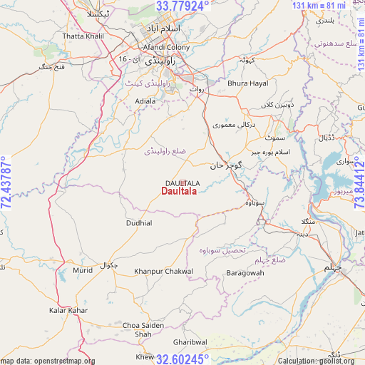
Daultala GPS coordinates[2]
33° 11' 34.152" North, 73° 8' 27.564" East
| Map corner | latitude | longitude |
|---|---|---|
| Upper-left | 33.77924°, | 72.43787° |
| Center: | 33.19282°, | 73.14099° |
| Lower-right: | 32.60245°, | 73.84412° |
| Map W x H: | 130.8×130.8 km | = 81.3×81.3mi |
| max Lat: | 36.32162° ⇑16.3% North |
| Daultala: | 33.19282° |
| min Lat: | ⇓83.7% South 24.14422° |
| min Long | Daultala | max Long |
| 61.74573° | 73.14099° | 75.63372° |
| W 75.8%⇐ | ⇒24.2% E |
Elevation
Elevation of Daultala is 547 m = 1795 ft, and this is 202 m = 663 ft above average elevation for this country.
| Max E: |
2732 m = 8963 ft | 16.7% |
| Daultala | 547 m 1795 ft | |
| Avg. | 345 m = 1132 ft | |
Min E: |
3 m = 10 ft | 83.3% |
See also: Pakistan elevation on elevation.city.
Geographical zone
Daultala is located in North temperate zone (between Tropic of Cancer and the Arctic Circle). Distance of this Northern Tropic circle is 1084.8 km =674.1 mi to South.| Distance of | km | miles | from Daultala |
|---|---|---|---|
| North Pole | 6316.4 | 3924.8 | to North |
| Arctic Circle | 3710.5 | 2305.6 | to North |
| Tropic Cancer | 1084.8 | 674.1 | to South |
| Equator | 3690.7 | 2293.3 | to South |


Nearby cities:
15 places around Daultala: (largest is in red/bold)
• Chakwal
39.4 km =24.5 mi,  222°
222°
• Choa Saidan Shah
54.6 km =33.9 mi,  195°
195°
• Dandot RS
63.2 km =39.3 mi,  194°
194°
• Gujar Khan
16.7 km =10.4 mi,  65°
65°
• Islamabad
59.5 km =37 mi,  351°
351°
• Jhelum
62 km =38.5 mi,  117°
117°
• Kahuta
49.9 km =31 mi,  27°
27°
• Kallar Kahar
61.8 km =38.4 mi, 221°
• Khandowa
62.8 km =39 mi, 217°
• Khewra
61.7 km =38.3 mi, 191°
• Nazir Town
34.2 km =21.3 mi, 68°
• New Mirpur
57.1 km =35.5 mi,  95°
95°
• Pind Dadan Khan
68 km =42.3 mi, 187°
• Rawalpindi
45.8 km =28.5 mi, 349°
• Sarai Alamgir
65.6 km =40.8 mi, 119°
Sources, notices
• [Note1] Compared only with cities in Pakistan existing in our database
• [Src1] Map data: © OpenStreetMap contributors (CC-BY-SA)
• [Src2] Other city data from geonames.org with taken over terms of usage.
• [Src3] Geographical zone / Annual Mean Temperature by Robert A. Rohde @ Wikipedia
