Chamber geodata
Chamber (Sindh) is a populated place; located in Pakistan in Asia/Karachi (GMT+5) time zone. With population of 12,746 people, there are 334 cities with bigger population in this country. Compared to other cities in Pakistan, 92.6% of cities are located further ↑North; 72.2% of cities are located further →East and 92.8% of cities have higher elevation than Chamber. Note1


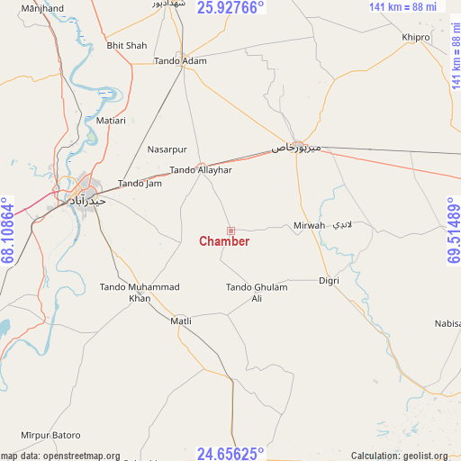
Chamber GPS coordinates[2]
25° 17' 37.032" North, 68° 48' 42.336" East
| Map corner | latitude | longitude |
|---|---|---|
| Upper-left | 25.92766°, | 68.10864° |
| Center: | 25.29362°, | 68.81176° |
| Lower-right: | 24.65625°, | 69.51489° |
| Map W x H: | 141.4×141.4 km | = 87.9×87.9mi |
| max Lat: | 36.32162° ⇑92.6% North |
| Chamber: | 25.29362° |
| min Lat: | ⇓7.4% South 24.14422° |
| min Long | Chamber | max Long |
| 61.74573° | 68.81176° | 75.63372° |
| W 27.8%⇐ | ⇒72.2% E |
Elevation
Elevation of Chamber is 20 m = 66 ft, and this is 325 m = 1066 ft below average elevation for this country.
| Max E: |
2732 m = 8963 ft | 92.8% |
| Avg. | 345 m = 1132 ft | |
| Chamber | 20 m = 66 ft | |
Min E: |
3 m = 10 ft | 7.2% |
See also: Pakistan elevation on elevation.city.
Geographical zone
Chamber is located in North temperate zone (between Tropic of Cancer and the Arctic Circle). Distance of this Northern Tropic circle is 206.5 km =128.3 mi to South.| Distance of | km | miles | from Chamber |
|---|---|---|---|
| North Pole | 7194.7 | 4470.6 | to North |
| Arctic Circle | 4588.8 | 2851.3 | to North |
| Tropic Cancer | 206.5 | 128.3 | to South |
| Equator | 2812.4 | 1747.5 | to South |


Nearby cities:
15 places around Chamber: (largest is in red/bold)
• Berani
54.6 km =33.9 mi,  359°
359°
• Digri
33.7 km =20.9 mi,  116°
116°
• Hyderabad
45.4 km =28.2 mi,  284°
284°
• Jamshoro
55.7 km =34.6 mi,  286°
286°
• Kotri
51.2 km =31.8 mi, 278°
• Matiari
49.8 km =30.9 mi,  312°
312°
• Matli
32 km =19.9 mi,  209°
209°
• Mirpur Khas
32.9 km =20.4 mi,  37°
37°
• Mirwah Gorchani
24 km =14.9 mi,  85°
85°
• Rajo Khanani
34.7 km =21.6 mi,  173°
173°
• Talhar
45.5 km =28.3 mi,  179°
179°
• Tando Adam
54.9 km =34.1 mi,  344°
344°
• Tando Allahyar
20.8 km =12.9 mi,  332°
332°
• Tando Jam
32.1 km =19.9 mi,  297°
297°
• Tando Muhammad Khan
33.5 km =20.8 mi,  235°
235°
Sources, notices
• [Note1] Compared only with cities in Pakistan existing in our database
• [Src1] Map data: © OpenStreetMap contributors (CC-BY-SA)
• [Src2] Other city data from geonames.org with taken over terms of usage.
• [Src3] Geographical zone / Annual Mean Temperature by Robert A. Rohde @ Wikipedia
