Matiari geodata
Matiari (Sindh) is a seat of a second-order administrative division; located in Pakistan in Asia/Karachi (GMT+5) time zone. With population of 18,929 people, there are 277 cities with bigger population in this country. Compared to other cities in Pakistan, 89.8% of cities are located further ↑North; 79.5% of cities are located further →East and 87.6% of cities have higher elevation than Matiari. Note1


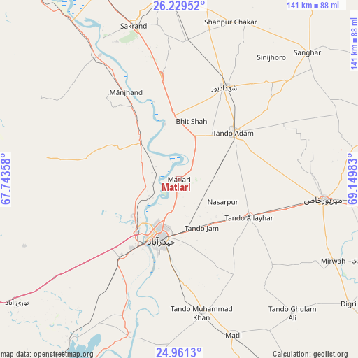
Matiari GPS coordinates[2]
25° 35' 49.524" North, 68° 26' 48.12" East
| Map corner | latitude | longitude |
|---|---|---|
| Upper-left | 26.22952°, | 67.74358° |
| Center: | 25.59709°, | 68.4467° |
| Lower-right: | 24.9613°, | 69.14983° |
| Map W x H: | 141×141 km | = 87.6×87.6mi |
| max Lat: | 36.32162° ⇑89.8% North |
| Matiari: | 25.59709° |
| min Lat: | ⇓10.2% South 24.14422° |
| min Long | Matiari | max Long |
| 61.74573° | 68.4467° | 75.63372° |
| W 20.5%⇐ | ⇒79.5% E |
Elevation
Elevation of Matiari is 36 m = 118 ft, and this is 309 m = 1014 ft below average elevation for this country.
| Max E: |
2732 m = 8963 ft | 87.6% |
| Avg. | 345 m = 1132 ft | |
| Matiari | 36 m = 118 ft | |
Min E: |
3 m = 10 ft | 12.4% |
See also: Pakistan elevation on elevation.city.
Geographical zone
Matiari is located in North temperate zone (between Tropic of Cancer and the Arctic Circle). Distance of this Northern Tropic circle is 240.2 km =149.3 mi to South.| Distance of | km | miles | from Matiari |
|---|---|---|---|
| North Pole | 7160.9 | 4449.6 | to North |
| Arctic Circle | 4555 | 2830.3 | to North |
| Tropic Cancer | 240.2 | 149.3 | to South |
| Equator | 2846.1 | 1768.5 | to South |


Nearby cities:
15 places around Matiari: (largest is in red/bold)
• Berani
41.8 km =26 mi,  59°
59°
• Bhit Shah
23.6 km =14.7 mi,  10°
10°
• Chamber
49.8 km =30.9 mi,  132°
132°
• Hala
24.3 km =15.1 mi,  354°
354°
• Hyderabad
23.9 km =14.9 mi,  197°
197°
• Jamshoro
24.5 km =15.2 mi,  223°
223°
• Jhol
59.5 km =37 mi,  48°
48°
• Kotri
29.2 km =18.1 mi,  208°
208°
• Mirpur Khas
57.3 km =35.6 mi,  97°
97°
• Sann
58.2 km =36.2 mi,  327°
327°
• Shahdadpur
40.5 km =25.2 mi,  25°
25°
• Tando Adam
28.8 km =17.9 mi, 48°
• Tando Allahyar
31.1 km =19.3 mi,  119°
119°
• Tando Jam
20.5 km =12.7 mi,  156°
156°
• Tando Muhammad Khan
53.4 km =33.2 mi,  170°
170°
Sources, notices
• [Note1] Compared only with cities in Pakistan existing in our database
• [Src1] Map data: © OpenStreetMap contributors (CC-BY-SA)
• [Src2] Other city data from geonames.org with taken over terms of usage.
• [Src3] Geographical zone / Annual Mean Temperature by Robert A. Rohde @ Wikipedia
