Mirpur Khas geodata
Mirpur Khas (Sindh) is a seat of a second-order administrative division; located in Pakistan in Asia/Karachi (GMT+5) time zone. With population of 215,657 people, there are 31 cities with bigger population in this country. Compared to other cities in Pakistan, 90.1% of cities are located further ↑North; 69.5% of cities are located further →East and 95.5% of cities have higher elevation than Mirpur Khas. Note1


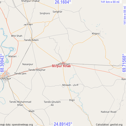
Mirpur Khas GPS coordinates[2]
25° 31' 39.36" North, 69° 0' 45.18" East
| Map corner | latitude | longitude |
|---|---|---|
| Upper-left | 26.1604°, | 68.30943° |
| Center: | 25.5276°, | 69.01255° |
| Lower-right: | 24.89145°, | 69.71568° |
| Map W x H: | 141.1×141.1 km | = 87.7×87.7mi |
| max Lat: | 36.32162° ⇑90.1% North |
| Mirpur Khas: | 25.5276° |
| min Lat: | ⇓9.9% South 24.14422° |
| min Long | Mirpur Khas | max Long |
| 61.74573° | 69.01255° | 75.63372° |
| W 30.5%⇐ | ⇒69.5% E |
Elevation
Elevation of Mirpur Khas is 14 m = 46 ft, and this is 331 m = 1086 ft below average elevation for this country.
| Max E: |
2732 m = 8963 ft | 95.5% |
| Avg. | 345 m = 1132 ft | |
| Mirpur Khas | 14 m = 46 ft | |
Min E: |
3 m = 10 ft | 4.5% |
See also: Mirpur Khas elevation on elevation.city.
Geographical zone
Mirpur Khas is located in North temperate zone (between Tropic of Cancer and the Arctic Circle). Distance of this Northern Tropic circle is 232.5 km =144.5 mi to South.| Distance of | km | miles | from Mirpur Khas |
|---|---|---|---|
| North Pole | 7168.7 | 4454.4 | to North |
| Arctic Circle | 4562.8 | 2835.2 | to North |
| Tropic Cancer | 232.5 | 144.5 | to South |
| Equator | 2838.4 | 1763.7 | to South |


Nearby cities:
15 places around Mirpur Khas: (largest is in red/bold)
• Berani
35.2 km =21.9 mi,  324°
324°
• Chamber
32.9 km =20.4 mi,  217°
217°
• Dhoro Naro
56.1 km =34.9 mi,  92°
92°
• Digri
42.4 km =26.3 mi,  166°
166°
• Jhol
49.1 km =30.5 mi,  345°
345°
• Matiari
57.3 km =35.6 mi,  277°
277°
• Mirwah Gorchani
24.5 km =15.2 mi, 171°
• Pithoro
36.7 km =22.8 mi, 92°
• Samaro
47.3 km =29.4 mi,  125°
125°
• Sanghar
58.1 km =36.1 mi, 353°
• Shahdadpur
59 km =36.7 mi, 318°
• Tando Adam
44.2 km =27.5 mi,  307°
307°
• Tando Allahyar
30.5 km =19 mi,  255°
255°
• Tando Jam
49.8 km =30.9 mi, 257°
• Tando Mitha Khan
55.5 km =34.5 mi,  20°
20°
Sources, notices
• [Note1] Compared only with cities in Pakistan existing in our database
• [Src1] Map data: © OpenStreetMap contributors (CC-BY-SA)
• [Src2] Other city data from geonames.org with taken over terms of usage.
• [Src3] Geographical zone / Annual Mean Temperature by Robert A. Rohde @ Wikipedia
