Digri geodata
Digri (Sindh) is a populated place; located in Pakistan in Asia/Karachi (GMT+5) time zone. With population of 31,842 people, there are 197 cities with bigger population in this country. Compared to other cities in Pakistan, 93.9% of cities are located further ↑North; 68.8% of cities are located further →East and 93.9% of cities have higher elevation than Digri. Note1


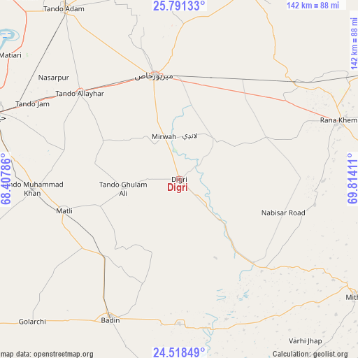
Digri GPS coordinates[2]
25° 9' 23.652" North, 69° 6' 39.528" East
| Map corner | latitude | longitude |
|---|---|---|
| Upper-left | 25.79133°, | 68.40786° |
| Center: | 25.15657°, | 69.11098° |
| Lower-right: | 24.51849°, | 69.81411° |
| Map W x H: | 141.5×141.5 km | = 87.9×87.9mi |
| max Lat: | 36.32162° ⇑93.9% North |
| Digri: | 25.15657° |
| min Lat: | ⇓6.1% South 24.14422° |
| min Long | Digri | max Long |
| 61.74573° | 69.11098° | 75.63372° |
| W 31.2%⇐ | ⇒68.8% E |
Elevation
Elevation of Digri is 18 m = 59 ft, and this is 327 m = 1073 ft below average elevation for this country.
| Max E: |
2732 m = 8963 ft | 93.9% |
| Avg. | 345 m = 1132 ft | |
| Digri | 18 m = 59 ft | |
Min E: |
3 m = 10 ft | 6.1% |
See also: Pakistan elevation on elevation.city.
Geographical zone
Digri is located in North temperate zone (between Tropic of Cancer and the Arctic Circle). Distance of this Northern Tropic circle is 191.2 km =118.8 mi to South.| Distance of | km | miles | from Digri |
|---|---|---|---|
| North Pole | 7209.9 | 4480 | to North |
| Arctic Circle | 4604 | 2860.8 | to North |
| Tropic Cancer | 191.2 | 118.8 | to South |
| Equator | 2797.1 | 1738 | to South |


Nearby cities:
15 places around Digri: (largest is in red/bold)
• Chamber
33.7 km =20.9 mi,  296°
296°
• Dhoro Naro
60.3 km =37.5 mi,  50°
50°
• Kunri
45.8 km =28.5 mi,  86°
86°
• Matli
47.5 km =29.5 mi,  254°
254°
• Mirpur Khas
42.4 km =26.3 mi,  346°
346°
• Mirwah Gorchani
18.1 km =11.2 mi,  340°
340°
• Nabisar
54.5 km =33.9 mi,  100°
100°
• Naukot
44.2 km =27.5 mi,  138°
138°
• Pithoro
47.7 km =29.6 mi,  34°
34°
• Rajo Khanani
32.2 km =20 mi,  233°
233°
• Samaro
31.9 km =19.8 mi,  64°
64°
• Talhar
42.5 km =26.4 mi,  224°
224°
• Tando Allahyar
52 km =32.3 mi,  310°
310°
• Tando Bago
43.4 km =27 mi,  199°
199°
• Tando Muhammad Khan
57.9 km =36 mi,  266°
266°
Sources, notices
• [Note1] Compared only with cities in Pakistan existing in our database
• [Src1] Map data: © OpenStreetMap contributors (CC-BY-SA)
• [Src2] Other city data from geonames.org with taken over terms of usage.
• [Src3] Geographical zone / Annual Mean Temperature by Robert A. Rohde @ Wikipedia
