Tando Allahyar geodata
Tando Allahyar (Sindh) is a seat of a second-order administrative division; located in Pakistan in Asia/Karachi (GMT+5) time zone. With population of 127,202 people, there are 49 cities with bigger population in this country. Compared to other cities in Pakistan, 91% of cities are located further ↑North; 74% of cities are located further →East and 91.9% of cities have higher elevation than Tando Allahyar. Note1


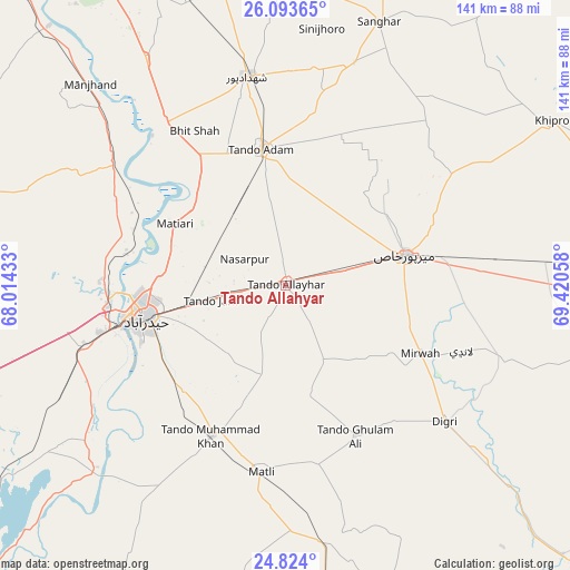
Tando Allahyar GPS coordinates[2]
25° 27' 37.8" North, 68° 43' 2.82" East
| Map corner | latitude | longitude |
|---|---|---|
| Upper-left | 26.09365°, | 68.01433° |
| Center: | 25.4605°, | 68.71745° |
| Lower-right: | 24.824°, | 69.42058° |
| Map W x H: | 141.2×141.2 km | = 87.7×87.7mi |
| max Lat: | 36.32162° ⇑91% North |
| Tando Allahyar: | 25.4605° |
| min Lat: | ⇓9% South 24.14422° |
| min Long | Tando Allahyar | max Long |
| 61.74573° | 68.71745° | 75.63372° |
| W 26%⇐ | ⇒74% E |
Elevation
Elevation of Tando Allahyar is 23 m = 75 ft, and this is 322 m = 1056 ft below average elevation for this country.
| Max E: |
2732 m = 8963 ft | 91.9% |
| Avg. | 345 m = 1132 ft | |
| Tando Allahyar | 23 m = 75 ft | |
Min E: |
3 m = 10 ft | 8.1% |
See also: Tando Allahyar elevation on elevation.city.
Geographical zone
Tando Allahyar is located in North temperate zone (between Tropic of Cancer and the Arctic Circle). Distance of this Northern Tropic circle is 225 km =139.8 mi to South.| Distance of | km | miles | from Tando Allahyar |
|---|---|---|---|
| North Pole | 7176.1 | 4459 | to North |
| Arctic Circle | 4570.2 | 2839.8 | to North |
| Tropic Cancer | 225 | 139.8 | to South |
| Equator | 2830.9 | 1759 | to South |


Nearby cities:
15 places around Tando Allahyar: (largest is in red/bold)
• Berani
37.2 km =23.1 mi,  14°
14°
• Bhit Shah
44.6 km =27.7 mi,  329°
329°
• Chamber
20.8 km =12.9 mi,  152°
152°
• Digri
52 km =32.3 mi,  130°
130°
• Hala
49.3 km =30.6 mi,  323°
323°
• Hyderabad
35.3 km =21.9 mi,  257°
257°
• Jamshoro
44 km =27.3 mi,  266°
266°
• Kotri
42.4 km =26.3 mi, 255°
• Matiari
31.1 km =19.3 mi,  299°
299°
• Matli
46.8 km =29.1 mi,  187°
187°
• Mirpur Khas
30.5 km =19 mi,  75°
75°
• Mirwah Gorchani
37.4 km =23.2 mi,  116°
116°
• Tando Adam
34.7 km =21.6 mi,  350°
350°
• Tando Jam
19.2 km =11.9 mi, 259°
• Tando Muhammad Khan
41.6 km =25.8 mi,  205°
205°
Sources, notices
• [Note1] Compared only with cities in Pakistan existing in our database
• [Src1] Map data: © OpenStreetMap contributors (CC-BY-SA)
• [Src2] Other city data from geonames.org with taken over terms of usage.
• [Src3] Geographical zone / Annual Mean Temperature by Robert A. Rohde @ Wikipedia
