Mirwah Gorchani geodata
Mirwah Gorchani (Sindh) is a populated place; located in Pakistan in Asia/Karachi (GMT+5) time zone. With population of 12,139 people, there are 339 cities with bigger population in this country. Compared to other cities in Pakistan, 92.3% of cities are located further ↑North; 69.3% of cities are located further →East and 93.9% of cities have higher elevation than Mirwah Gorchani. Note1


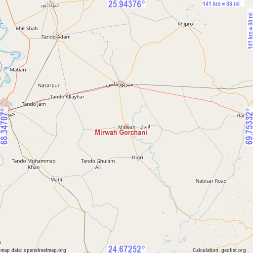
Mirwah Gorchani GPS coordinates[2]
25° 18' 35.316" North, 69° 3' 0.684" East
| Map corner | latitude | longitude |
|---|---|---|
| Upper-left | 25.94376°, | 68.34707° |
| Center: | 25.30981°, | 69.05019° |
| Lower-right: | 24.67252°, | 69.75332° |
| Map W x H: | 141.3×141.4 km | = 87.8×87.9mi |
| max Lat: | 36.32162° ⇑92.3% North |
| Mirwah Gorchani: | 25.30981° |
| min Lat: | ⇓7.7% South 24.14422° |
| min Long | Mirwah Gorchani | max Long |
| 61.74573° | 69.05019° | 75.63372° |
| W 30.7%⇐ | ⇒69.3% E |
Elevation
Elevation of Mirwah Gorchani is 18 m = 59 ft, and this is 327 m = 1073 ft below average elevation for this country.
| Max E: |
2732 m = 8963 ft | 93.9% |
| Avg. | 345 m = 1132 ft | |
| Mirwah Gorchani | 18 m = 59 ft | |
Min E: |
3 m = 10 ft | 6.1% |
See also: Pakistan elevation on elevation.city.
Geographical zone
Mirwah Gorchani is located in North temperate zone (between Tropic of Cancer and the Arctic Circle). Distance of this Northern Tropic circle is 208.3 km =129.4 mi to South.| Distance of | km | miles | from Mirwah Gorchani |
|---|---|---|---|
| North Pole | 7192.9 | 4469.5 | to North |
| Arctic Circle | 4587 | 2850.2 | to North |
| Tropic Cancer | 208.3 | 129.4 | to South |
| Equator | 2814.2 | 1748.7 | to South |


Nearby cities:
15 places around Mirwah Gorchani: (largest is in red/bold)
• Berani
58.2 km =36.2 mi,  335°
335°
• Chamber
24 km =14.9 mi,  265°
265°
• Dhoro Naro
56.6 km =35.2 mi,  67°
67°
• Digri
18.1 km =11.2 mi,  160°
160°
• Kunri
53.9 km =33.5 mi,  105°
105°
• Matli
49.5 km =30.8 mi,  233°
233°
• Mirpur Khas
24.5 km =15.2 mi,  351°
351°
• Pithoro
39.8 km =24.7 mi,  55°
55°
• Rajo Khanani
41.3 km =25.7 mi,  208°
208°
• Samaro
34.9 km =21.7 mi,  95°
95°
• Talhar
52.9 km =32.9 mi, 206°
• Tando Allahyar
37.4 km =23.2 mi,  296°
296°
• Tando Bago
58.5 km =36.4 mi,  188°
188°
• Tando Jam
54 km =33.6 mi,  284°
284°
• Tando Muhammad Khan
55.6 km =34.5 mi,  248°
248°
Sources, notices
• [Note1] Compared only with cities in Pakistan existing in our database
• [Src1] Map data: © OpenStreetMap contributors (CC-BY-SA)
• [Src2] Other city data from geonames.org with taken over terms of usage.
• [Src3] Geographical zone / Annual Mean Temperature by Robert A. Rohde @ Wikipedia
