Lalian geodata
Lalian (Punjab) is a populated place; located in Pakistan in Asia/Karachi (GMT+5) time zone. With population of 31,355 people, there are 202 cities with bigger population in this country. Compared to other cities in Pakistan, 62.8% of cities are located further ↓South; 69.1% of cities are located further ←West and 50.1% of cities have higher elevation than Lalian. Note1


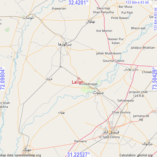
Lalian GPS coordinates[2]
31° 49' 28.632" North, 72° 48' 4.176" East
| Map corner | latitude | longitude |
|---|---|---|
| Upper-left | 32.4201°, | 72.09804° |
| Center: | 31.82462°, | 72.80116° |
| Lower-right: | 31.22527°, | 73.50429° |
| Map W x H: | 132.9×132.9 km | = 82.6×82.6mi |
| max Lat: | 36.32162° ⇑37.2% North |
| Lalian: | 31.82462° |
| min Lat: | ⇓62.8% South 24.14422° |
| min Long | Lalian | max Long |
| 61.74573° | 72.80116° | 75.63372° |
| W 69.1%⇐ | ⇒30.9% E |
Elevation
Elevation of Lalian is 179 m = 587 ft, and this is 166 m = 545 ft below average elevation for this country.
| Max E: |
2732 m = 8963 ft | 50.1% |
| Avg. | 345 m = 1132 ft | |
| Lalian | 179 m = 587 ft | |
Min E: |
3 m = 10 ft | 49.9% |
See also: Pakistan elevation on elevation.city.
Geographical zone
Lalian is located in North temperate zone (between Tropic of Cancer and the Arctic Circle). Distance of this Northern Tropic circle is 932.6 km =579.5 mi to South.| Distance of | km | miles | from Lalian |
|---|---|---|---|
| North Pole | 6468.5 | 4019.3 | to North |
| Arctic Circle | 3862.6 | 2400.1 | to North |
| Tropic Cancer | 932.6 | 579.5 | to South |
| Equator | 3538.6 | 2198.8 | to South |


Nearby cities:
15 places around Lalian: (largest is in red/bold)
• Bhalwal
49.9 km =31 mi,  10°
10°
• Bhawana
31.9 km =19.8 mi,  206°
206°
• Chak Jhumra
46 km =28.6 mi,  128°
128°
• Chenab Nagar
13.2 km =8.2 mi, 125°
• Chiniot
20.3 km =12.6 mi,  124°
124°
• Faisalabad
53.1 km =33 mi,  149°
149°
• Faruka
37.2 km =23.1 mi,  280°
280°
• Jahanian Shah
49.5 km =30.8 mi,  267°
267°
• Kot Mumin
45.8 km =28.5 mi,  28°
28°
• Liliani
44.5 km =27.7 mi,  18°
18°
• Mangla
40.3 km =25 mi, 280°
• Pindi Bhattian
45.3 km =28.1 mi,  79°
79°
• Sahiwal
47.4 km =29.5 mi,  290°
290°
• Sargodha
31.4 km =19.5 mi,  337°
337°
• Sillanwali
24.6 km =15.3 mi, 270°
Sources, notices
• [Note1] Compared only with cities in Pakistan existing in our database
• [Src1] Map data: © OpenStreetMap contributors (CC-BY-SA)
• [Src2] Other city data from geonames.org with taken over terms of usage.
• [Src3] Geographical zone / Annual Mean Temperature by Robert A. Rohde @ Wikipedia
