Sargodha geodata
Sargodha (Punjab) is a seat of a second-order administrative division; located in Pakistan in Asia/Karachi (GMT+5) time zone. With population of 542,603 people, there are 15 cities with bigger population in this country. Compared to other cities in Pakistan, 67% of cities are located further ↓South; 67.5% of cities are located further ←West and 55.5% of cities have lower elevation than Sargodha. Note1


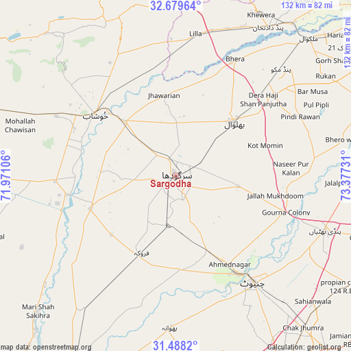
Sargodha GPS coordinates[2]
32° 5' 9.096" North, 72° 40' 27.048" East
| Map corner | latitude | longitude |
|---|---|---|
| Upper-left | 32.67964°, | 71.97106° |
| Center: | 32.08586°, | 72.67418° |
| Lower-right: | 31.4882°, | 73.37731° |
| Map W x H: | 132.5×132.5 km | = 82.3×82.3mi |
| max Lat: | 36.32162° ⇑33% North |
| Sargodha: | 32.08586° |
| min Lat: | ⇓67% South 24.14422° |
| min Long | Sargodha | max Long |
| 61.74573° | 72.67418° | 75.63372° |
| W 67.5%⇐ | ⇒32.5% E |
Elevation
Elevation of Sargodha is 193 m = 633 ft, and this is 152 m = 499 ft below average elevation for this country.
| Max E: |
2732 m = 8963 ft | 44.5% |
| Avg. | 345 m = 1132 ft | |
| Sargodha | 193 m = 633 ft | |
Min E: |
3 m = 10 ft | 55.5% |
See also: Sargodha elevation on elevation.city.
Geographical zone
Sargodha is located in North temperate zone (between Tropic of Cancer and the Arctic Circle). Distance of this Northern Tropic circle is 961.7 km =597.6 mi to South.| Distance of | km | miles | from Sargodha |
|---|---|---|---|
| North Pole | 6439.4 | 4001.3 | to North |
| Arctic Circle | 3833.6 | 2382.1 | to North |
| Tropic Cancer | 961.7 | 597.6 | to South |
| Equator | 3567.6 | 2216.8 | to South |


Nearby cities:
15 places around Sargodha: (largest is in red/bold)
• Bhalwal
29.1 km =18.1 mi,  46°
46°
• Chenab Nagar
43.2 km =26.8 mi,  148°
148°
• Faruka
33.1 km =20.6 mi,  227°
227°
• Jahanian Shah
48.7 km =30.3 mi, 230°
• Jauharabad
43.3 km =26.9 mi,  301°
301°
• Jhawarian
31.1 km =19.3 mi,  351°
351°
• Keshupur
25.4 km =15.8 mi,  319°
319°
• Khushāb
38.3 km =23.8 mi,  307°
307°
• Kot Mumin
35.4 km =22 mi,  71°
71°
• Lalian
31.4 km =19.5 mi,  157°
157°
• Liliani
29.2 km =18.1 mi,  63°
63°
• Mangla
34.9 km =21.7 mi, 232°
• Sahiwal
34.7 km =21.6 mi,  248°
248°
• Shahpur
28 km =17.4 mi, 316°
• Sillanwali
31.6 km =19.6 mi,  203°
203°
Sources, notices
• [Note1] Compared only with cities in Pakistan existing in our database
• [Src1] Map data: © OpenStreetMap contributors (CC-BY-SA)
• [Src2] Other city data from geonames.org with taken over terms of usage.
• [Src3] Geographical zone / Annual Mean Temperature by Robert A. Rohde @ Wikipedia
