Krzeszów geodata
Krzeszów (Lesser Poland) is a populated place; located in Poland in Europe/Warsaw (GMT+2) time zone. With population of 1,618 people, there are 1745 cities with bigger population in this country. Compared to other cities in Poland, 92.9% of cities are located further ↑North; 51.1% of cities are located further →East and 97.8% of cities have lower elevation than Krzeszów. Note1


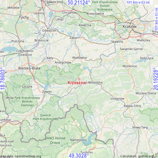
Krzeszów GPS coordinates[2]
49° 45' 32.94" North, 19° 29' 20.94" East
| Map corner | latitude | longitude |
|---|---|---|
| Upper-left | 50.21124°, | 18.78603° |
| Center: | 49.75915°, | 19.48915° |
| Lower-right: | 49.3028°, | 20.19228° |
| Map W x H: | 101×101 km | = 62.8×62.8mi |
| max Lat: | 54.83135° ⇑92.9% North |
| Krzeszów: | 49.75915° |
| min Lat: | ⇓7.1% South 49.21328° |
| min Long | Krzeszów | max Long |
| 14.20249° | 19.48915° | 24.03723° |
| W 48.9%⇐ | ⇒51.1% E |
Elevation
Elevation of Krzeszów is 504 m = 1654 ft, and this is 312.6 m = 1026 ft above average elevation for this country.
| Max E: |
974 m = 3196 ft | 2.2% |
| Krzeszów | 504 m 1654 ft | |
| Avg. | 191.4 m = 628 ft | |
Min E: |
-3 m = -10 ft | 97.8% |
See also: Poland elevation on elevation.city.
Geographical zone
Krzeszów is located in North temperate zone (between Tropic of Cancer and the Arctic Circle). Distance of this North polar circle is 1868.5 km =1161 mi to North.| Distance of | km | miles | from Krzeszów |
|---|---|---|---|
| North Pole | 4474.4 | 2780.3 | to North |
| Arctic Circle | 1868.5 | 1161 | to North |
| Tropic Cancer | 2926.8 | 1818.6 | to South |
| Equator | 5532.7 | 3437.9 | to South |


Nearby cities:
15 places around Krzeszów: (largest is in red/bold)
• Jaroszowice
11.7 km =7.3 mi,  10°
10°
• Kuków
3 km =1.9 mi,  185°
185°
• Kurów
5.7 km =3.5 mi,  222°
222°
• Lachowice
5 km =3.1 mi, 192°
• Marcówka
10 km =6.2 mi,  68°
68°
• Mucharz
7.2 km =4.5 mi,  35°
35°
• Ponikiew
8.4 km =5.2 mi,  348°
348°
• Rzyki
8.8 km =5.5 mi,  310°
310°
• Stryszawa
5.6 km =3.5 mi,  155°
155°
• Sucha Beskidzka
7.8 km =4.8 mi,  104°
104°
• Sułkowice
11.4 km =7.1 mi, 305°
• Zagórnik
11.7 km =7.3 mi,  317°
317°
• Zembrzyce
8.2 km =5.1 mi,  77°
77°
• Ślemień
9.9 km =6.2 mi,  242°
242°
• Świnna Poręba
8.9 km =5.5 mi,  15°
15°
Sources, notices
• [Note1] Compared only with cities in Poland existing in our database
• [Src1] Map data: © OpenStreetMap contributors (CC-BY-SA)
• [Src2] Other city data from geonames.org with taken over terms of usage.
• [Src3] Geographical zone / Annual Mean Temperature by Robert A. Rohde @ Wikipedia
