Zamarski geodata
Zamarski (Silesia) is a populated place; located in Poland in Europe/Warsaw (GMT+2) time zone. With population of 1,279 people, there are 2104 cities with bigger population in this country. Compared to other cities in Poland, 92.4% of cities are located further ↑North; 65.5% of cities are located further →East and 93.4% of cities have lower elevation than Zamarski. Note1


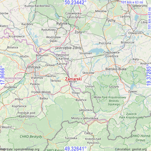
Zamarski GPS coordinates[2]
49° 46' 57.144" North, 18° 40' 10.992" East
| Map corner | latitude | longitude |
|---|---|---|
| Upper-left | 50.23442°, | 17.9666° |
| Center: | 49.78254°, | 18.66972° |
| Lower-right: | 49.32641°, | 19.37285° |
| Map W x H: | 101×101 km | = 62.8×62.8mi |
| max Lat: | 54.83135° ⇑92.4% North |
| Zamarski: | 49.78254° |
| min Lat: | ⇓7.6% South 49.21328° |
| min Long | Zamarski | max Long |
| 14.20249° | 18.66972° | 24.03723° |
| W 34.5%⇐ | ⇒65.5% E |
Elevation
Elevation of Zamarski is 378 m = 1240 ft, and this is 186.6 m = 612 ft above average elevation for this country.
| Max E: |
974 m = 3196 ft | 6.6% |
| Zamarski | 378 m 1240 ft | |
| Avg. | 191.4 m = 628 ft | |
Min E: |
-3 m = -10 ft | 93.4% |
See also: Poland elevation on elevation.city.
Geographical zone
Zamarski is located in North temperate zone (between Tropic of Cancer and the Arctic Circle). Distance of this North polar circle is 1865.9 km =1159.4 mi to North.| Distance of | km | miles | from Zamarski |
|---|---|---|---|
| North Pole | 4471.8 | 2778.6 | to North |
| Arctic Circle | 1865.9 | 1159.4 | to North |
| Tropic Cancer | 2929.4 | 1820.2 | to South |
| Equator | 5535.3 | 3439.5 | to South |


Nearby cities:
15 places around Zamarski: (largest is in red/bold)
• Bażanowice
5.5 km =3.4 mi,  153°
153°
• Cieszyn
4.4 km =2.7 mi,  217°
217°
• Dzięgielów
7.1 km =4.4 mi,  159°
159°
• Dębowiec
5.1 km =3.2 mi,  46°
46°
• Goleszów
7.1 km =4.4 mi,  137°
137°
• Hażlach
3 km =1.9 mi,  334°
334°
• Iskrzyczyn
5.5 km =3.4 mi,  74°
74°
• Kaczyce
7.5 km =4.7 mi,  311°
311°
• Kostkowice
2.6 km =1.6 mi,  59°
59°
• Kończyce Wielkie
6.1 km =3.8 mi,  342°
342°
• Miedzyświec
6.8 km =4.2 mi,  88°
88°
• Ogrodzona
4.5 km =2.8 mi,  110°
110°
• Pogwizdów
5.5 km =3.4 mi,  295°
295°
• Puńców
7.2 km =4.5 mi,  184°
184°
• Simoradz
7.3 km =4.5 mi, 63°
Sources, notices
• [Note1] Compared only with cities in Poland existing in our database
• [Src1] Map data: © OpenStreetMap contributors (CC-BY-SA)
• [Src2] Other city data from geonames.org with taken over terms of usage.
• [Src3] Geographical zone / Annual Mean Temperature by Robert A. Rohde @ Wikipedia
