Hażlach geodata
Hażlach (Silesia) is a populated place; located in Poland in Europe/Warsaw (GMT+2) time zone. With population of 2,175 people, there are 1382 cities with bigger population in this country. Compared to other cities in Poland, 91.5% of cities are located further ↑North; 65.6% of cities are located further →East and 83.4% of cities have lower elevation than Hażlach. Note1


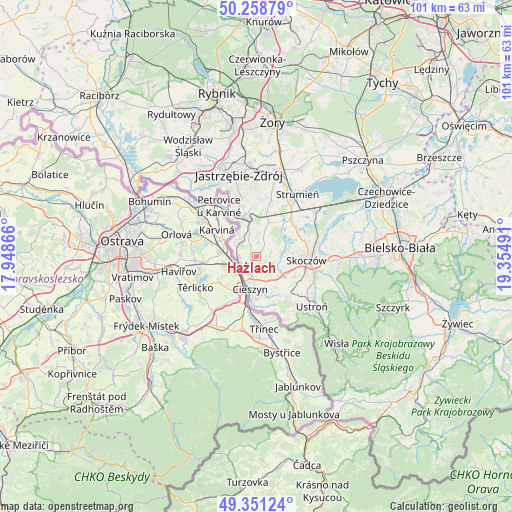
Hażlach GPS coordinates[2]
49° 48' 25.704" North, 18° 39' 6.408" East
| Map corner | latitude | longitude |
|---|---|---|
| Upper-left | 50.25879°, | 17.94866° |
| Center: | 49.80714°, | 18.65178° |
| Lower-right: | 49.35124°, | 19.35491° |
| Map W x H: | 100.9×100.9 km | = 62.7×62.7mi |
| max Lat: | 54.83135° ⇑91.5% North |
| Hażlach: | 49.80714° |
| min Lat: | ⇓8.5% South 49.21328° |
| min Long | Hażlach | max Long |
| 14.20249° | 18.65178° | 24.03723° |
| W 34.4%⇐ | ⇒65.6% E |
Elevation
Elevation of Hażlach is 282 m = 925 ft, and this is 90.6 m = 297 ft above average elevation for this country.
| Max E: |
974 m = 3196 ft | 16.6% |
| Hażlach | 282 m 925 ft | |
| Avg. | 191.4 m = 628 ft | |
Min E: |
-3 m = -10 ft | 83.4% |
See also: Poland elevation on elevation.city.
Geographical zone
Hażlach is located in North temperate zone (between Tropic of Cancer and the Arctic Circle). Distance of this North polar circle is 1863.1 km =1157.7 mi to North.| Distance of | km | miles | from Hażlach |
|---|---|---|---|
| North Pole | 4469 | 2776.9 | to North |
| Arctic Circle | 1863.1 | 1157.7 | to North |
| Tropic Cancer | 2932.1 | 1821.9 | to South |
| Equator | 5538 | 3441.2 | to South |


Nearby cities:
15 places around Hażlach: (largest is in red/bold)
• Bażanowice
8.5 km =5.3 mi,  154°
154°
• Cieszyn
6.4 km =4 mi,  192°
192°
• Dębowiec
5 km =3.1 mi,  81°
81°
• Iskrzyczyn
6.7 km =4.2 mi,  100°
100°
• Kaczyce
4.9 km =3 mi,  297°
297°
• Kostkowice
3.8 km =2.4 mi,  111°
111°
• Kończyce Małe
5.9 km =3.7 mi,  344°
344°
• Kończyce Wielkie
3.1 km =1.9 mi,  350°
350°
• Miedzyświec
8.5 km =5.3 mi, 107°
• Ogrodzona
7 km =4.3 mi,  128°
128°
• Pogwizdów
3.7 km =2.3 mi,  264°
264°
• Pruchna
6.8 km =4.2 mi,  18°
18°
• Simoradz
7.8 km =4.8 mi,  86°
86°
• Zamarski
3 km =1.9 mi, 154°
• Zebrzydowice
8.4 km =5.2 mi, 339°
Sources, notices
• [Note1] Compared only with cities in Poland existing in our database
• [Src1] Map data: © OpenStreetMap contributors (CC-BY-SA)
• [Src2] Other city data from geonames.org with taken over terms of usage.
• [Src3] Geographical zone / Annual Mean Temperature by Robert A. Rohde @ Wikipedia
