Cieszyn geodata
Cieszyn (Silesia) is a seat of a third-order administrative division; located in Poland in Europe/Warsaw (GMT+2) time zone. With population of 35,586 people, there are 147 cities with bigger population in this country. Compared to other cities in Poland, 93.1% of cities are located further ↑North; 66% of cities are located further →East and 81.4% of cities have lower elevation than Cieszyn. Note1


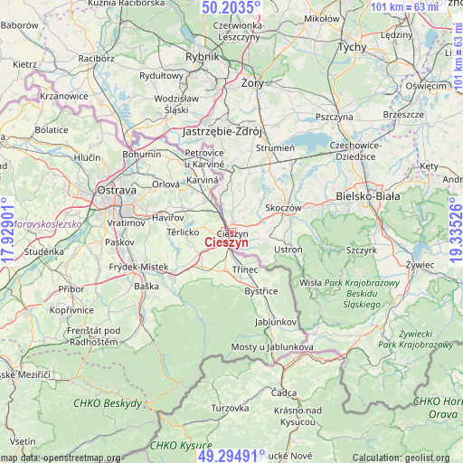
Cieszyn GPS coordinates[2]
49° 45' 4.788" North, 18° 37' 55.668" East
| Map corner | latitude | longitude |
|---|---|---|
| Upper-left | 50.2035°, | 17.92901° |
| Center: | 49.75133°, | 18.63213° |
| Lower-right: | 49.29491°, | 19.33526° |
| Map W x H: | 101×101 km | = 62.8×62.8mi |
| max Lat: | 54.83135° ⇑93.1% North |
| Cieszyn: | 49.75133° |
| min Lat: | ⇓6.9% South 49.21328° |
| min Long | Cieszyn | max Long |
| 14.20249° | 18.63213° | 24.03723° |
| W 34%⇐ | ⇒66% E |
Elevation
Elevation of Cieszyn is 273 m = 896 ft, and this is 81.6 m = 268 ft above average elevation for this country.
| Max E: |
974 m = 3196 ft | 18.6% |
| Cieszyn | 273 m 896 ft | |
| Avg. | 191.4 m = 628 ft | |
Min E: |
-3 m = -10 ft | 81.4% |
See also: Poland elevation on elevation.city.
Geographical zone
Cieszyn is located in North temperate zone (between Tropic of Cancer and the Arctic Circle). Distance of this North polar circle is 1869.3 km =1161.5 mi to North.| Distance of | km | miles | from Cieszyn |
|---|---|---|---|
| North Pole | 4475.2 | 2780.8 | to North |
| Arctic Circle | 1869.3 | 1161.5 | to North |
| Tropic Cancer | 2925.9 | 1818.1 | to South |
| Equator | 5531.8 | 3437.3 | to South |


Nearby cities:
15 places around Cieszyn: (largest is in red/bold)
• Bażanowice
5.3 km =3.3 mi,  106°
106°
• Cisownica
9.9 km =6.2 mi, 108°
• Dzięgielów
6.1 km =3.8 mi,  121°
121°
• Dębowiec
9.4 km =5.8 mi,  42°
42°
• Goleszów
7.7 km =4.8 mi,  102°
102°
• Hażlach
6.4 km =4 mi,  12°
12°
• Iskrzyczyn
9.4 km =5.8 mi,  58°
58°
• Kaczyce
9 km =5.6 mi,  341°
341°
• Kostkowice
6.9 km =4.3 mi,  45°
45°
• Kończyce Wielkie
9.4 km =5.8 mi, 5°
• Miedzyświec
10.2 km =6.3 mi,  69°
69°
• Ogrodzona
7.2 km =4.5 mi,  75°
75°
• Pogwizdów
6.2 km =3.9 mi, 339°
• Puńców
4.2 km =2.6 mi,  149°
149°
• Zamarski
4.4 km =2.7 mi, 37°
Sources, notices
• [Note1] Compared only with cities in Poland existing in our database
• [Src1] Map data: © OpenStreetMap contributors (CC-BY-SA)
• [Src2] Other city data from geonames.org with taken over terms of usage.
• [Src3] Geographical zone / Annual Mean Temperature by Robert A. Rohde @ Wikipedia
