Dębowiec geodata
Dębowiec (Silesia) is a populated place; located in Poland in Europe/Warsaw (GMT+2) time zone. With population of 1,786 people, there are 1637 cities with bigger population in this country. Compared to other cities in Poland, 91.2% of cities are located further ↑North; 64.8% of cities are located further →East and 83.6% of cities have lower elevation than Dębowiec. Note1


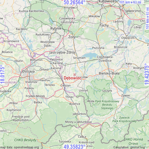
Dębowiec GPS coordinates[2]
49° 48' 50.616" North, 18° 43' 14.232" East
| Map corner | latitude | longitude |
|---|---|---|
| Upper-left | 50.26564°, | 18.0175° |
| Center: | 49.81406°, | 18.72062° |
| Lower-right: | 49.35823°, | 19.42375° |
| Map W x H: | 100.9×100.9 km | = 62.7×62.7mi |
| max Lat: | 54.83135° ⇑91.2% North |
| Dębowiec: | 49.81406° |
| min Lat: | ⇓8.8% South 49.21328° |
| min Long | Dębowiec | max Long |
| 14.20249° | 18.72062° | 24.03723° |
| W 35.2%⇐ | ⇒64.8% E |
Elevation
Elevation of Dębowiec is 283 m = 928 ft, and this is 91.6 m = 301 ft above average elevation for this country.
| Max E: |
974 m = 3196 ft | 16.4% |
| Dębowiec | 283 m 928 ft | |
| Avg. | 191.4 m = 628 ft | |
Min E: |
-3 m = -10 ft | 83.6% |
See also: Poland elevation on elevation.city.
Geographical zone
Dębowiec is located in North temperate zone (between Tropic of Cancer and the Arctic Circle). Distance of this North polar circle is 1862.4 km =1157.2 mi to North.| Distance of | km | miles | from Dębowiec |
|---|---|---|---|
| North Pole | 4468.3 | 2776.5 | to North |
| Arctic Circle | 1862.4 | 1157.2 | to North |
| Tropic Cancer | 2932.9 | 1822.4 | to South |
| Equator | 5538.8 | 3441.6 | to South |


Nearby cities:
15 places around Dębowiec: (largest is in red/bold)
• Bładnice
5.8 km =3.6 mi,  133°
133°
• Drogomyśl
6.7 km =4.2 mi,  23°
23°
• Hażlach
5 km =3.1 mi,  261°
261°
• Iskrzyczyn
2.6 km =1.6 mi,  140°
140°
• Kiczyce
6 km =3.7 mi,  78°
78°
• Kostkowice
2.6 km =1.6 mi,  212°
212°
• Kończyce Wielkie
5.9 km =3.7 mi,  293°
293°
• Miedzyświec
4.6 km =2.9 mi, 136°
• Ochaby
4.7 km =2.9 mi,  47°
47°
• Ogrodzona
5.2 km =3.2 mi,  173°
173°
• Pruchna
6.3 km =3.9 mi,  334°
334°
• Simoradz
2.8 km =1.7 mi,  94°
94°
• Skoczów
5 km =3.1 mi,  106°
106°
• Wiślica
4.5 km =2.8 mi, 80°
• Zamarski
5.1 km =3.2 mi,  226°
226°
Sources, notices
• [Note1] Compared only with cities in Poland existing in our database
• [Src1] Map data: © OpenStreetMap contributors (CC-BY-SA)
• [Src2] Other city data from geonames.org with taken over terms of usage.
• [Src3] Geographical zone / Annual Mean Temperature by Robert A. Rohde @ Wikipedia
