Bażanowice geodata
Bażanowice (Silesia) is a populated place; located in Poland in Europe/Warsaw (GMT+2) time zone. With population of 1,161 people, there are 2246 cities with bigger population in this country. Compared to other cities in Poland, 93.3% of cities are located further ↑North; 65% of cities are located further →East and 87.3% of cities have lower elevation than Bażanowice. Note1


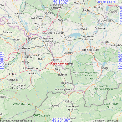
Bażanowice GPS coordinates[2]
49° 44' 16.476" North, 18° 42' 12.42" East
| Map corner | latitude | longitude |
|---|---|---|
| Upper-left | 50.1902°, | 18.00033° |
| Center: | 49.73791°, | 18.70345° |
| Lower-right: | 49.28136°, | 19.40658° |
| Map W x H: | 101.1×101.1 km | = 62.8×62.8mi |
| max Lat: | 54.83135° ⇑93.3% North |
| Bażanowice: | 49.73791° |
| min Lat: | ⇓6.7% South 49.21328° |
| min Long | Bażanowice | max Long |
| 14.20249° | 18.70345° | 24.03723° |
| W 35%⇐ | ⇒65% E |
Elevation
Elevation of Bażanowice is 303 m = 994 ft, and this is 111.6 m = 366 ft above average elevation for this country.
| Max E: |
974 m = 3196 ft | 12.7% |
| Bażanowice | 303 m 994 ft | |
| Avg. | 191.4 m = 628 ft | |
Min E: |
-3 m = -10 ft | 87.3% |
See also: Poland elevation on elevation.city.
Geographical zone
Bażanowice is located in North temperate zone (between Tropic of Cancer and the Arctic Circle). Distance of this North polar circle is 1870.8 km =1162.5 mi to North.| Distance of | km | miles | from Bażanowice |
|---|---|---|---|
| North Pole | 4476.7 | 2781.7 | to North |
| Arctic Circle | 1870.8 | 1162.5 | to North |
| Tropic Cancer | 2924.4 | 1817.1 | to South |
| Equator | 5530.3 | 3436.4 | to South |


Nearby cities:
15 places around Bażanowice: (largest is in red/bold)
• Bładnice
7.1 km =4.4 mi,  50°
50°
• Cieszyn
5.3 km =3.3 mi,  286°
286°
• Cisownica
4.5 km =2.8 mi,  111°
111°
• Dzięgielów
1.7 km =1.1 mi,  176°
176°
• Dębowiec
8.6 km =5.3 mi,  8°
8°
• Goleszów
2.4 km =1.5 mi,  95°
95°
• Harbutowice
8.8 km =5.5 mi,  58°
58°
• Hażlach
8.5 km =5.3 mi,  334°
334°
• Iskrzyczyn
7.1 km =4.4 mi,  24°
24°
• Kostkowice
6.3 km =3.9 mi,  358°
358°
• Miedzyświec
6.8 km =4.2 mi,  40°
40°
• Ogrodzona
3.8 km =2.4 mi,  28°
28°
• Puńców
3.7 km =2.3 mi,  234°
234°
• Ustroń
7.3 km =4.5 mi, 104°
• Zamarski
5.5 km =3.4 mi, 333°
Sources, notices
• [Note1] Compared only with cities in Poland existing in our database
• [Src1] Map data: © OpenStreetMap contributors (CC-BY-SA)
• [Src2] Other city data from geonames.org with taken over terms of usage.
• [Src3] Geographical zone / Annual Mean Temperature by Robert A. Rohde @ Wikipedia
