Wleń geodata
Wleń (Lower Silesia) is a seat of a third-order administrative division; located in Poland in Europe/Warsaw (GMT+2) time zone. With population of 1,888 people, there are 1570 cities with bigger population in this country. Compared to other cities in Poland, 55% of cities are located further ↑North; 94.5% of cities are located further →East and 70.4% of cities have lower elevation than Wleń. Note1


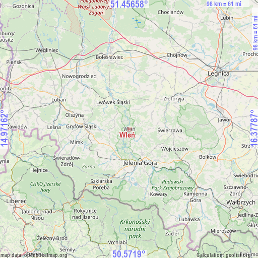
Wleń GPS coordinates[2]
51° 0' 58.86" North, 15° 40' 29.064" East
| Map corner | latitude | longitude |
|---|---|---|
| Upper-left | 51.45658°, | 14.97162° |
| Center: | 51.01635°, | 15.67474° |
| Lower-right: | 50.5719°, | 16.37787° |
| Map W x H: | 98.4×98.4 km | = 61.1×61.1mi |
| max Lat: | 54.83135° ⇑55% North |
| Wleń: | 51.01635° |
| min Lat: | ⇓45% South 49.21328° |
| min Long | Wleń | max Long |
| 14.20249° | 15.67474° | 24.03723° |
| W 5.5%⇐ | ⇒94.5% E |
Elevation
Elevation of Wleń is 230 m = 755 ft, and this is 38.6 m = 127 ft above average elevation for this country.
| Max E: |
974 m = 3196 ft | 29.6% |
| Wleń | 230 m 755 ft | |
| Avg. | 191.4 m = 628 ft | |
Min E: |
-3 m = -10 ft | 70.4% |
See also: Poland elevation on elevation.city.
Geographical zone
Wleń is located in North temperate zone (between Tropic of Cancer and the Arctic Circle). Distance of this North polar circle is 1728.7 km =1074.2 mi to North.| Distance of | km | miles | from Wleń |
|---|---|---|---|
| North Pole | 4334.6 | 2693.4 | to North |
| Arctic Circle | 1728.7 | 1074.2 | to North |
| Tropic Cancer | 3066.6 | 1905.5 | to South |
| Equator | 5672.5 | 3524.7 | to South |


Nearby cities:
15 places around Wleń: (largest is in red/bold)
• Cieplice Śląskie Zdrój
16.8 km =10.4 mi,  177°
177°
• Gryfów Śląski
17.9 km =11.1 mi,  275°
275°
• Jelenia Góra
13.5 km =8.4 mi,  163°
163°
• Jeżów Sudecki
10.2 km =6.3 mi,  152°
152°
• Lubomierz
11.6 km =7.2 mi,  268°
268°
• Lwówek Śląski
12.2 km =7.6 mi,  329°
329°
• Pasiecznik
9.8 km =6.1 mi,  227°
227°
• Piechowice
19.3 km =12 mi,  196°
196°
• Pielgrzymka
14.7 km =9.1 mi,  41°
41°
• Pilchowice
4.9 km =3 mi,  211°
211°
• Rybnica
11.6 km =7.2 mi, 198°
• Stara Kamienica
13.2 km =8.2 mi, 212°
• Sędziszowa
14.1 km =8.8 mi,  85°
85°
• Wojcieszów
18.7 km =11.6 mi,  112°
112°
• Świerzawa
15.4 km =9.6 mi, 91°
Sources, notices
• [Note1] Compared only with cities in Poland existing in our database
• [Src1] Map data: © OpenStreetMap contributors (CC-BY-SA)
• [Src2] Other city data from geonames.org with taken over terms of usage.
• [Src3] Geographical zone / Annual Mean Temperature by Robert A. Rohde @ Wikipedia
