Sędziszowa geodata
Sędziszowa (Lower Silesia) is a populated place; located in Poland in Europe/Warsaw (GMT+2) time zone. With population of 581 people, there are 3332 cities with bigger population in this country. Compared to other cities in Poland, 54.6% of cities are located further ↑North; 93.2% of cities are located further →East and 77.2% of cities have lower elevation than Sędziszowa. Note1


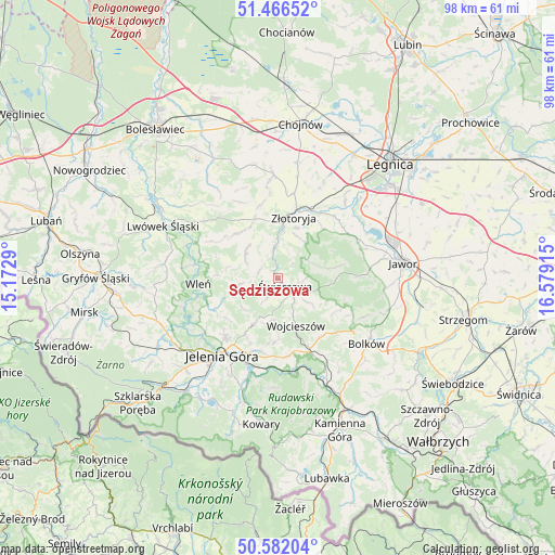
Sędziszowa GPS coordinates[2]
51° 1' 35.004" North, 15° 52' 33.672" East
| Map corner | latitude | longitude |
|---|---|---|
| Upper-left | 51.46652°, | 15.1729° |
| Center: | 51.02639°, | 15.87602° |
| Lower-right: | 50.58204°, | 16.57915° |
| Map W x H: | 98.3×98.3 km | = 61.1×61.1mi |
| max Lat: | 54.83135° ⇑54.6% North |
| Sędziszowa: | 51.02639° |
| min Lat: | ⇓45.4% South 49.21328° |
| min Long | Sędziszowa | max Long |
| 14.20249° | 15.87602° | 24.03723° |
| W 6.8%⇐ | ⇒93.2% E |
Elevation
Elevation of Sędziszowa is 255 m = 837 ft, and this is 63.6 m = 209 ft above average elevation for this country.
| Max E: |
974 m = 3196 ft | 22.8% |
| Sędziszowa | 255 m 837 ft | |
| Avg. | 191.4 m = 628 ft | |
Min E: |
-3 m = -10 ft | 77.2% |
See also: Poland elevation on elevation.city.
Geographical zone
Sędziszowa is located in North temperate zone (between Tropic of Cancer and the Arctic Circle). Distance of this North polar circle is 1727.6 km =1073.5 mi to North.| Distance of | km | miles | from Sędziszowa |
|---|---|---|---|
| North Pole | 4333.5 | 2692.7 | to North |
| Arctic Circle | 1727.6 | 1073.5 | to North |
| Tropic Cancer | 3067.7 | 1906.2 | to South |
| Equator | 5673.6 | 3525.4 | to South |


Nearby cities:
15 places around Sędziszowa: (largest is in red/bold)
• Bolków
19.6 km =12.2 mi,  126°
126°
• Janowice Wielkie
17.1 km =10.6 mi,  168°
168°
• Jelenia Góra
17.4 km =10.8 mi,  216°
216°
• Jeżów Sudecki
13.8 km =8.6 mi, 222°
• Krotoszyce
17.9 km =11.1 mi,  41°
41°
• Męcinka
16.3 km =10.1 mi,  71°
71°
• Paszowice
19.4 km =12.1 mi,  95°
95°
• Pielgrzymka
10.9 km =6.8 mi,  336°
336°
• Pilchowice
17.4 km =10.8 mi,  252°
252°
• Wilków
8.2 km =5.1 mi,  26°
26°
• Wleń
14.1 km =8.8 mi,  265°
265°
• Wojcieszów
8.9 km =5.5 mi,  158°
158°
• Zagrodno
18.4 km =11.4 mi,  357°
357°
• Złotoryja
11.5 km =7.1 mi,  15°
15°
• Świerzawa
1.9 km =1.2 mi,  136°
136°
Sources, notices
• [Note1] Compared only with cities in Poland existing in our database
• [Src1] Map data: © OpenStreetMap contributors (CC-BY-SA)
• [Src2] Other city data from geonames.org with taken over terms of usage.
• [Src3] Geographical zone / Annual Mean Temperature by Robert A. Rohde @ Wikipedia
