Wilcza geodata
Wilcza (Silesia) is a populated place; located in Poland in Europe/Warsaw (GMT+2) time zone. With population of 2,063 people, there are 1445 cities with bigger population in this country. Compared to other cities in Poland, 75% of cities are located further ↑North; 66.8% of cities are located further →East and 75.8% of cities have lower elevation than Wilcza. Note1


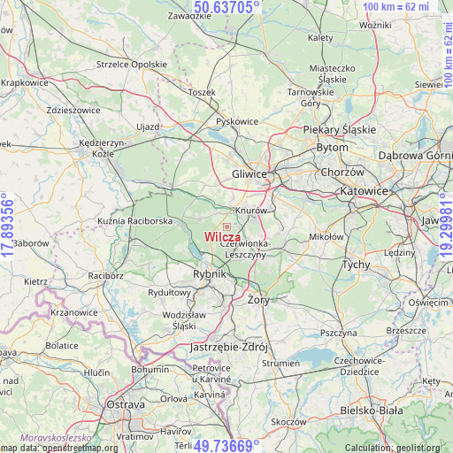
Wilcza GPS coordinates[2]
50° 11' 20.364" North, 18° 35' 48.048" East
| Map corner | latitude | longitude |
|---|---|---|
| Upper-left | 50.63705°, | 17.89356° |
| Center: | 50.18899°, | 18.59668° |
| Lower-right: | 49.73669°, | 19.29981° |
| Map W x H: | 100.1×100.1 km | = 62.2×62.2mi |
| max Lat: | 54.83135° ⇑75% North |
| Wilcza: | 50.18899° |
| min Lat: | ⇓25% South 49.21328° |
| min Long | Wilcza | max Long |
| 14.20249° | 18.59668° | 24.03723° |
| W 33.2%⇐ | ⇒66.8% E |
Elevation
Elevation of Wilcza is 249 m = 817 ft, and this is 57.6 m = 189 ft above average elevation for this country.
| Max E: |
974 m = 3196 ft | 24.2% |
| Wilcza | 249 m 817 ft | |
| Avg. | 191.4 m = 628 ft | |
Min E: |
-3 m = -10 ft | 75.8% |
See also: Poland elevation on elevation.city.
Geographical zone
Wilcza is located in North temperate zone (between Tropic of Cancer and the Arctic Circle). Distance of this North polar circle is 1820.7 km =1131.3 mi to North.| Distance of | km | miles | from Wilcza |
|---|---|---|---|
| North Pole | 4426.6 | 2750.6 | to North |
| Arctic Circle | 1820.7 | 1131.3 | to North |
| Tropic Cancer | 2974.6 | 1848.3 | to South |
| Equator | 5580.5 | 3467.6 | to South |


Nearby cities:
15 places around Wilcza: (largest is in red/bold)
• Bełk
10.7 km =6.6 mi,  127°
127°
• Czerwionka-Leszczyny
7.2 km =4.5 mi, 126°
• Gierałtowice
10.5 km =6.5 mi,  67°
67°
• Jejkowice
12.9 km =8 mi,  225°
225°
• Knurów
5.1 km =3.2 mi,  48°
48°
• Książenice
3.8 km =2.4 mi,  177°
177°
• Ornontowice
11.2 km =7 mi,  87°
87°
• Pilchowice
4 km =2.5 mi,  320°
320°
• Przyszowice
12.5 km =7.8 mi,  58°
58°
• Rudy
10.2 km =6.3 mi,  270°
270°
• Rybnik
10.9 km =6.8 mi,  200°
200°
• Sośnicowice
10.4 km =6.5 mi,  332°
332°
• Stanowice
8.4 km =5.2 mi,  140°
140°
• Zebrzydowice
12.1 km =7.5 mi,  214°
214°
• Żernica
6.7 km =4.2 mi,  11°
11°
Sources, notices
• [Note1] Compared only with cities in Poland existing in our database
• [Src1] Map data: © OpenStreetMap contributors (CC-BY-SA)
• [Src2] Other city data from geonames.org with taken over terms of usage.
• [Src3] Geographical zone / Annual Mean Temperature by Robert A. Rohde @ Wikipedia
