Stanowice geodata
Stanowice (Silesia) is a populated place; located in Poland in Europe/Warsaw (GMT+2) time zone. With population of 2,254 people, there are 1336 cities with bigger population in this country. Compared to other cities in Poland, 76.9% of cities are located further ↑North; 65.5% of cities are located further →East and 80% of cities have lower elevation than Stanowice. Note1


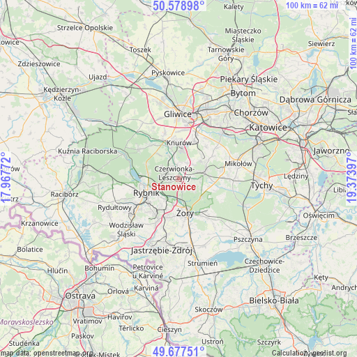
Stanowice GPS coordinates[2]
50° 7' 49.332" North, 18° 40' 15.024" East
| Map corner | latitude | longitude |
|---|---|---|
| Upper-left | 50.57898°, | 17.96772° |
| Center: | 50.13037°, | 18.67084° |
| Lower-right: | 49.67751°, | 19.37397° |
| Map W x H: | 100.2×100.2 km | = 62.3×62.3mi |
| max Lat: | 54.83135° ⇑76.9% North |
| Stanowice: | 50.13037° |
| min Lat: | ⇓23.1% South 49.21328° |
| min Long | Stanowice | max Long |
| 14.20249° | 18.67084° | 24.03723° |
| W 34.5%⇐ | ⇒65.5% E |
Elevation
Elevation of Stanowice is 266 m = 873 ft, and this is 74.6 m = 245 ft above average elevation for this country.
| Max E: |
974 m = 3196 ft | 20% |
| Stanowice | 266 m 873 ft | |
| Avg. | 191.4 m = 628 ft | |
Min E: |
-3 m = -10 ft | 80% |
See also: Poland elevation on elevation.city.
Geographical zone
Stanowice is located in North temperate zone (between Tropic of Cancer and the Arctic Circle). Distance of this North polar circle is 1827.2 km =1135.4 mi to North.| Distance of | km | miles | from Stanowice |
|---|---|---|---|
| North Pole | 4433.1 | 2754.6 | to North |
| Arctic Circle | 1827.2 | 1135.4 | to North |
| Tropic Cancer | 2968.1 | 1844.3 | to South |
| Equator | 5574 | 3463.5 | to South |


Nearby cities:
15 places around Stanowice: (largest is in red/bold)
• Bełk
3.3 km =2.1 mi,  89°
89°
• Czerwionka-Leszczyny
2.2 km =1.4 mi,  12°
12°
• Gardawice
9.3 km =5.8 mi,  99°
99°
• Gierałtowice
11.4 km =7.1 mi,  23°
23°
• Knurów
10 km =6.2 mi,  351°
351°
• Książenice
5.8 km =3.6 mi,  298°
298°
• Ornontowice
9.2 km =5.7 mi,  40°
40°
• Orzesze
8.2 km =5.1 mi,  69°
69°
• Pilchowice
12.4 km =7.7 mi,  320°
320°
• Rudziczka
12.3 km =7.6 mi,  148°
148°
• Rybnik
9.9 km =6.2 mi,  248°
248°
• Wilcza
8.4 km =5.2 mi, 320°
• Zebrzydowice
12.6 km =7.8 mi, 254°
• Łaziska Górne
12.4 km =7.7 mi,  80°
80°
• Żory
9.7 km =6 mi,  167°
167°
Sources, notices
• [Note1] Compared only with cities in Poland existing in our database
• [Src1] Map data: © OpenStreetMap contributors (CC-BY-SA)
• [Src2] Other city data from geonames.org with taken over terms of usage.
• [Src3] Geographical zone / Annual Mean Temperature by Robert A. Rohde @ Wikipedia
