Knurów geodata
Knurów (Silesia) is a seat of a third-order administrative division; located in Poland in Europe/Warsaw (GMT+2) time zone. With population of 39,744 people, there are 129 cities with bigger population in this country. Compared to other cities in Poland, 74.1% of cities are located further ↑North; 65.7% of cities are located further →East and 72.1% of cities have lower elevation than Knurów. Note1


Knurów GPS coordinates[2]
50° 13' 10.956" North, 18° 39' 2.412" East
| Map corner | latitude | longitude |
|---|---|---|
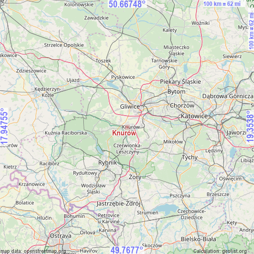
| Upper-left | 50.66748°, | 17.94755° |
| Center: | 50.21971°, | 18.65067° |
| Lower-right: | 49.7677°, | 19.3538° |
| Map W x H: | 100×100 km | = 62.1×62.1mi |
| max Lat: | 54.83135° ⇑74.1% North |
| Knurów: | 50.21971° |
| min Lat: | ⇓25.9% South 49.21328° |
| min Long | Knurów | max Long |
| 14.20249° | 18.65067° | 24.03723° |
| W 34.3%⇐ | ⇒65.7% E |
Elevation
Elevation of Knurów is 236 m = 774 ft, and this is 44.6 m = 146 ft above average elevation for this country.
| Max E: |
974 m = 3196 ft | 27.9% |
| Knurów | 236 m 774 ft | |
| Avg. | 191.4 m = 628 ft | |
Min E: |
-3 m = -10 ft | 72.1% |
See also: Poland elevation on elevation.city.
Geographical zone
Knurów is located in North temperate zone (between Tropic of Cancer and the Arctic Circle). Distance of this North polar circle is 1817.3 km =1129.2 mi to North.| Distance of | km | miles | from Knurów |
|---|---|---|---|
| North Pole | 4423.2 | 2748.4 | to North |
| Arctic Circle | 1817.3 | 1129.2 | to North |
| Tropic Cancer | 2978 | 1850.4 | to South |
| Equator | 5583.9 | 3469.7 | to South |


Nearby cities:
15 places around Knurów: (largest is in red/bold)
• Bełk
11 km =6.8 mi,  154°
154°
• Czerwionka-Leszczyny
8 km =5 mi,  166°
166°
• Gierałtowice
5.9 km =3.7 mi,  84°
84°
• Gliwice
8.9 km =5.5 mi,  12°
12°
• Kozłów
11.5 km =7.1 mi,  327°
327°
• Książenice
8 km =5 mi,  207°
207°
• Ornontowice
7.9 km =4.9 mi,  111°
111°
• Orzesze
11.6 km =7.2 mi,  127°
127°
• Paniówki
9.4 km =5.8 mi, 82°
• Pilchowice
6.4 km =4 mi,  266°
266°
• Przyszowice
7.5 km =4.7 mi,  64°
64°
• Sośnicowice
10.4 km =6.5 mi,  304°
304°
• Stanowice
10 km =6.2 mi, 171°
• Wilcza
5.1 km =3.2 mi,  228°
228°
• Żernica
4 km =2.5 mi,  321°
321°
Sources, notices
• [Note1] Compared only with cities in Poland existing in our database
• [Src1] Map data: © OpenStreetMap contributors (CC-BY-SA)
• [Src2] Other city data from geonames.org with taken over terms of usage.
• [Src3] Geographical zone / Annual Mean Temperature by Robert A. Rohde @ Wikipedia
