Czerwionka-Leszczyny geodata
Czerwionka-Leszczyny (Silesia) is a seat of a third-order administrative division; located in Poland in Europe/Warsaw (GMT+2) time zone. With population of 28,740 people, there are 171 cities with bigger population in this country. Compared to other cities in Poland, 76% of cities are located further ↑North; 65.4% of cities are located further →East and 76.8% of cities have lower elevation than Czerwionka-Leszczyny. Note1


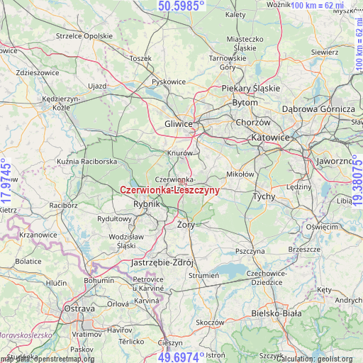
Czerwionka-Leszczyny GPS coordinates[2]
50° 9' 0.252" North, 18° 40' 39.432" East
| Map corner | latitude | longitude |
|---|---|---|
| Upper-left | 50.5985°, | 17.9745° |
| Center: | 50.15007°, | 18.67762° |
| Lower-right: | 49.6974°, | 19.38075° |
| Map W x H: | 100.2×100.2 km | = 62.3×62.3mi |
| max Lat: | 54.83135° ⇑76% North |
| Czerwionka-Leszczyny: | 50.15007° |
| min Lat: | ⇓24% South 49.21328° |
| min Long | Czerwionka-Lesz | max Long |
| 14.20249° | 18.67762° | 24.03723° |
| W 34.6%⇐ | ⇒65.4% E |
Elevation
Elevation of Czerwionka-Leszczyny is 253 m = 830 ft, and this is 61.6 m = 202 ft above average elevation for this country.
| Max E: |
974 m = 3196 ft | 23.2% |
| Czerwionka-Leszczyny | 253 m 830 ft | |
| Avg. | 191.4 m = 628 ft | |
Min E: |
-3 m = -10 ft | 76.8% |
See also: Poland elevation on elevation.city.
Geographical zone
Czerwionka-Leszczyny is located in North temperate zone (between Tropic of Cancer and the Arctic Circle). Distance of this North polar circle is 1825 km =1134 mi to North.| Distance of | km | miles | from Czerwionka-Leszczyny |
|---|---|---|---|
| North Pole | 4430.9 | 2753.2 | to North |
| Arctic Circle | 1825 | 1134 | to North |
| Tropic Cancer | 2970.2 | 1845.6 | to South |
| Equator | 5576.2 | 3464.9 | to South |


Nearby cities:
15 places around Czerwionka-Leszczyny: (largest is in red/bold)
• Bełk
3.5 km =2.2 mi,  128°
128°
• Gardawice
9.5 km =5.9 mi,  113°
113°
• Gierałtowice
9.2 km =5.7 mi,  25°
25°
• Knurów
8 km =5 mi,  346°
346°
• Książenice
5.6 km =3.5 mi,  275°
275°
• Ornontowice
7.3 km =4.5 mi,  48°
48°
• Orzesze
7.3 km =4.5 mi,  84°
84°
• Paniówki
11.7 km =7.3 mi,  39°
39°
• Pilchowice
11.1 km =6.9 mi,  311°
311°
• Rybnik
11.3 km =7 mi,  238°
238°
• Stanowice
2.2 km =1.4 mi,  192°
192°
• Wilcza
7.2 km =4.5 mi, 306°
• Łaziska Górne
11.7 km =7.3 mi,  90°
90°
• Żernica
11.7 km =7.3 mi,  337°
337°
• Żory
11.8 km =7.3 mi,  171°
171°
Sources, notices
• [Note1] Compared only with cities in Poland existing in our database
• [Src1] Map data: © OpenStreetMap contributors (CC-BY-SA)
• [Src2] Other city data from geonames.org with taken over terms of usage.
• [Src3] Geographical zone / Annual Mean Temperature by Robert A. Rohde @ Wikipedia
