Sośnicowice geodata
Sośnicowice (Silesia) is a seat of a third-order administrative division; located in Poland in Europe/Warsaw (GMT+2) time zone. With population of 1,691 people, there are 1704 cities with bigger population in this country. Compared to other cities in Poland, 72.7% of cities are located further ↑North; 67.6% of cities are located further →East and 74.5% of cities have lower elevation than Sośnicowice. Note1


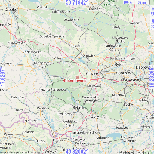
Sośnicowice GPS coordinates[2]
50° 16' 19.704" North, 18° 31' 47.352" East
| Map corner | latitude | longitude |
|---|---|---|
| Upper-left | 50.71942°, | 17.8267° |
| Center: | 50.27214°, | 18.52982° |
| Lower-right: | 49.82062°, | 19.23295° |
| Map W x H: | 99.9×99.9 km | = 62.1×62.1mi |
| max Lat: | 54.83135° ⇑72.7% North |
| Sośnicowice: | 50.27214° |
| min Lat: | ⇓27.3% South 49.21328° |
| min Long | Sośnicowice | max Long |
| 14.20249° | 18.52982° | 24.03723° |
| W 32.4%⇐ | ⇒67.6% E |
Elevation
Elevation of Sośnicowice is 244 m = 801 ft, and this is 52.6 m = 173 ft above average elevation for this country.
| Max E: |
974 m = 3196 ft | 25.5% |
| Sośnicowice | 244 m 801 ft | |
| Avg. | 191.4 m = 628 ft | |
Min E: |
-3 m = -10 ft | 74.5% |
See also: Poland elevation on elevation.city.
Geographical zone
Sośnicowice is located in North temperate zone (between Tropic of Cancer and the Arctic Circle). Distance of this North polar circle is 1811.4 km =1125.6 mi to North.| Distance of | km | miles | from Sośnicowice |
|---|---|---|---|
| North Pole | 4417.3 | 2744.8 | to North |
| Arctic Circle | 1811.4 | 1125.6 | to North |
| Tropic Cancer | 2983.8 | 1854 | to South |
| Equator | 5589.7 | 3473.3 | to South |


Nearby cities:
15 places around Sośnicowice: (largest is in red/bold)
• Czerwionka-Leszczyny
17.2 km =10.7 mi,  142°
142°
• Gierałtowice
15.4 km =9.6 mi,  109°
109°
• Gliwice
10.8 km =6.7 mi,  74°
74°
• Kleszczów
8.4 km =5.2 mi,  358°
358°
• Knurów
10.4 km =6.5 mi,  124°
124°
• Kozłów
4.6 km =2.9 mi,  31°
31°
• Książenice
13.9 km =8.6 mi,  159°
159°
• Kuźnia Raciborska
17.4 km =10.8 mi,  242°
242°
• Pilchowice
6.6 km =4.1 mi, 160°
• Przyszowice
15.6 km =9.7 mi,  99°
99°
• Pyskowice
16 km =9.9 mi, 27°
• Rudy
10.6 km =6.6 mi,  210°
210°
• Rudziniec
12.4 km =7.7 mi,  316°
316°
• Wilcza
10.4 km =6.5 mi,  152°
152°
• Żernica
6.7 km =4.2 mi, 114°
Sources, notices
• [Note1] Compared only with cities in Poland existing in our database
• [Src1] Map data: © OpenStreetMap contributors (CC-BY-SA)
• [Src2] Other city data from geonames.org with taken over terms of usage.
• [Src3] Geographical zone / Annual Mean Temperature by Robert A. Rohde @ Wikipedia
