Iłowa geodata
Iłowa (Lubusz) is a populated place; located in Poland in Europe/Warsaw (GMT+2) time zone. With population of 4,085 people, there are 802 cities with bigger population in this country. Compared to other cities in Poland, 56.3% of cities are located further ↓South; 96.9% of cities are located further →East and 67.8% of cities have higher elevation than Iłowa. Note1


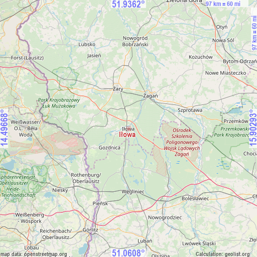
Iłowa GPS coordinates[2]
51° 30' 2.16" North, 15° 11' 59.28" East
| Map corner | latitude | longitude |
|---|---|---|
| Upper-left | 51.9362°, | 14.49668° |
| Center: | 51.5006°, | 15.1998° |
| Lower-right: | 51.0608°, | 15.90293° |
| Map W x H: | 97.3×97.3 km | = 60.5×60.5mi |
| max Lat: | 54.83135° ⇑43.7% North |
| Iłowa: | 51.5006° |
| min Lat: | ⇓56.3% South 49.21328° |
| min Long | Iłowa | max Long |
| 14.20249° | 15.1998° | 24.03723° |
| W 3.1%⇐ | ⇒96.9% E |
Elevation
Elevation of Iłowa is 126 m = 413 ft, and this is 65.4 m = 215 ft below average elevation for this country.
| Max E: |
974 m = 3196 ft | 67.8% |
| Avg. | 191.4 m = 628 ft | |
| Iłowa | 126 m = 413 ft | |
Min E: |
-3 m = -10 ft | 32.2% |
See also: Poland elevation on elevation.city.
Geographical zone
Iłowa is located in North temperate zone (between Tropic of Cancer and the Arctic Circle). Distance of this North polar circle is 1674.8 km =1040.7 mi to North.| Distance of | km | miles | from Iłowa |
|---|---|---|---|
| North Pole | 4280.7 | 2659.9 | to North |
| Arctic Circle | 1674.8 | 1040.7 | to North |
| Tropic Cancer | 3120.4 | 1938.9 | to South |
| Equator | 5726.3 | 3558.2 | to South |


Nearby cities:
15 places around Iłowa: (largest is in red/bold)
• Brzeźnica
27.3 km =17 mi,  29°
29°
• Gozdnica
10 km =6.2 mi,  224°
224°
• Kunice Żarskie
11.3 km =7 mi,  347°
347°
• Lipinki Łużyckie
20.8 km =12.9 mi,  318°
318°
• Małomice
18.4 km =11.4 mi,  70°
70°
• Osiecznica
24.6 km =15.3 mi,  141°
141°
• Pieńsk
29.9 km =18.6 mi,  200°
200°
• Przewóz
17.3 km =10.7 mi,  262°
262°
• Sieniawa Żarska
18.3 km =11.4 mi,  328°
328°
• Szprotawa
24.4 km =15.2 mi, 72°
• Trzebiel
30.4 km =18.9 mi,  299°
299°
• Wymiarki
8.2 km =5.1 mi,  278°
278°
• Węgliniec
23.8 km =14.8 mi,  175°
175°
• Żagań
15.2 km =9.4 mi, 31°
• Żary
16.3 km =10.1 mi,  344°
344°
Sources, notices
• [Note1] Compared only with cities in Poland existing in our database
• [Src1] Map data: © OpenStreetMap contributors (CC-BY-SA)
• [Src2] Other city data from geonames.org with taken over terms of usage.
• [Src3] Geographical zone / Annual Mean Temperature by Robert A. Rohde @ Wikipedia
