Warlubie geodata
Warlubie (Kujawsko-Pomorskie) is a populated place; located in Poland in Europe/Warsaw (GMT+2) time zone. With population of 2,043 people, there are 1451 cities with bigger population in this country. Compared to other cities in Poland, 90.6% of cities are located further ↓South; 65.9% of cities are located further →East and 90.6% of cities have higher elevation than Warlubie. Note1


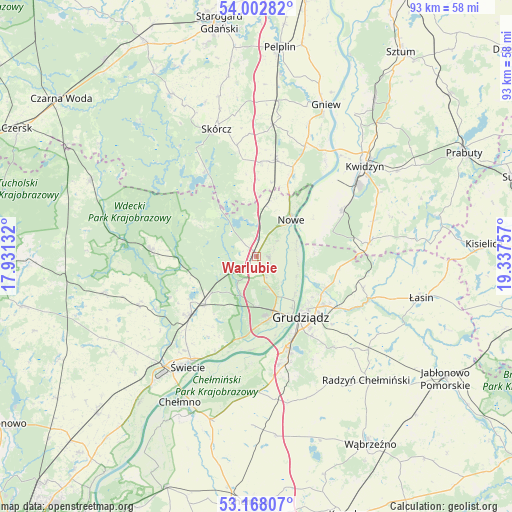
Warlubie GPS coordinates[2]
53° 35' 15.036" North, 18° 38' 3.984" East
| Map corner | latitude | longitude |
|---|---|---|
| Upper-left | 54.00282°, | 17.93132° |
| Center: | 53.58751°, | 18.63444° |
| Lower-right: | 53.16807°, | 19.33757° |
| Map W x H: | 92.8×92.8 km | = 57.7×57.7mi |
| max Lat: | 54.83135° ⇑9.4% North |
| Warlubie: | 53.58751° |
| min Lat: | ⇓90.6% South 49.21328° |
| min Long | Warlubie | max Long |
| 14.20249° | 18.63444° | 24.03723° |
| W 34.1%⇐ | ⇒65.9% E |
Elevation
Elevation of Warlubie is 72 m = 236 ft, and this is 119.4 m = 392 ft below average elevation for this country.
| Max E: |
974 m = 3196 ft | 90.6% |
| Avg. | 191.4 m = 628 ft | |
| Warlubie | 72 m = 236 ft | |
Min E: |
-3 m = -10 ft | 9.4% |
See also: Poland elevation on elevation.city.
Geographical zone
Warlubie is located in North temperate zone (between Tropic of Cancer and the Arctic Circle). Distance of this North polar circle is 1442.8 km =896.5 mi to North.| Distance of | km | miles | from Warlubie |
|---|---|---|---|
| North Pole | 4048.7 | 2515.7 | to North |
| Arctic Circle | 1442.8 | 896.5 | to North |
| Tropic Cancer | 3352.5 | 2083.1 | to South |
| Equator | 5958.4 | 3702.4 | to South |


Nearby cities:
15 places around Warlubie: (largest is in red/bold)
• Dragasz
11.4 km =7.1 mi,  142°
142°
• Drzycim
23.3 km =14.5 mi,  246°
246°
• Gardeja
20.8 km =12.9 mi,  82°
82°
• Grudziądz
13.9 km =8.6 mi,  145°
145°
• Jeżewo
12.6 km =7.8 mi,  227°
227°
• Kopytkowo
16.7 km =10.4 mi,  3°
3°
• Kwidzyn
24.8 km =15.4 mi,  51°
51°
• Nowe
9.2 km =5.7 mi,  41°
41°
• Osie
19.2 km =11.9 mi,  273°
273°
• Osiek
17.7 km =11 mi,  327°
327°
• Rogóźno
20.3 km =12.6 mi,  106°
106°
• Sadlinki
17.7 km =11 mi,  60°
60°
• Skórcz
24.1 km =15 mi,  342°
342°
• Smętowo Graniczne
18 km =11.2 mi,  10°
10°
• Świecie
23.3 km =14.5 mi,  212°
212°
Sources, notices
• [Note1] Compared only with cities in Poland existing in our database
• [Src1] Map data: © OpenStreetMap contributors (CC-BY-SA)
• [Src2] Other city data from geonames.org with taken over terms of usage.
• [Src3] Geographical zone / Annual Mean Temperature by Robert A. Rohde @ Wikipedia
