Sadlinki geodata
Sadlinki (Pomerania) is a populated place; located in Poland in Europe/Warsaw (GMT+2) time zone. With population of 1,987 people, there are 1505 cities with bigger population in this country. Compared to other cities in Poland, 91.1% of cities are located further ↓South; 62.4% of cities are located further →East and 97.9% of cities have higher elevation than Sadlinki. Note1


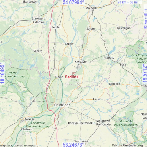
Sadlinki GPS coordinates[2]
53° 39' 55.404" North, 18° 52' 5.052" East
| Map corner | latitude | longitude |
|---|---|---|
| Upper-left | 54.07994°, | 18.16495° |
| Center: | 53.66539°, | 18.86807° |
| Lower-right: | 53.24673°, | 19.5712° |
| Map W x H: | 92.6×92.6 km | = 57.5×57.5mi |
| max Lat: | 54.83135° ⇑8.9% North |
| Sadlinki: | 53.66539° |
| min Lat: | ⇓91.1% South 49.21328° |
| min Long | Sadlinki | max Long |
| 14.20249° | 18.86807° | 24.03723° |
| W 37.6%⇐ | ⇒62.4% E |
Elevation
Elevation of Sadlinki is 16 m = 52 ft, and this is 175.4 m = 575 ft below average elevation for this country.
| Max E: |
974 m = 3196 ft | 97.9% |
| Avg. | 191.4 m = 628 ft | |
| Sadlinki | 16 m = 52 ft | |
Min E: |
-3 m = -10 ft | 2.1% |
See also: Poland elevation on elevation.city.
Geographical zone
Sadlinki is located in North temperate zone (between Tropic of Cancer and the Arctic Circle). Distance of this North polar circle is 1434.1 km =891.1 mi to North.| Distance of | km | miles | from Sadlinki |
|---|---|---|---|
| North Pole | 4040 | 2510.3 | to North |
| Arctic Circle | 1434.1 | 891.1 | to North |
| Tropic Cancer | 3361.1 | 2088.5 | to South |
| Equator | 5967 | 3707.7 | to South |


Nearby cities:
15 places around Sadlinki: (largest is in red/bold)
• Dragasz
19.7 km =12.2 mi,  205°
205°
• Gardeja
8 km =5 mi,  139°
139°
• Gniew
19.2 km =11.9 mi,  351°
351°
• Grudziądz
21.5 km =13.4 mi,  200°
200°
• Gruta
24.3 km =15.1 mi,  166°
166°
• Kopytkowo
16.5 km =10.3 mi,  299°
299°
• Kwidzyn
7.8 km =4.8 mi,  32°
32°
• Morzeszczyn
22.6 km =14 mi,  329°
329°
• Nowe
9.5 km =5.9 mi,  258°
258°
• Prabuty
24.3 km =15.1 mi,  65°
65°
• Rogóźno
14.9 km =9.3 mi,  164°
164°
• Ryjewo
20.8 km =12.9 mi,  17°
17°
• Smętowo Graniczne
15 km =9.3 mi,  306°
306°
• Warlubie
17.7 km =11 mi,  240°
240°
• Łasin
21.9 km =13.6 mi, 138°
Sources, notices
• [Note1] Compared only with cities in Poland existing in our database
• [Src1] Map data: © OpenStreetMap contributors (CC-BY-SA)
• [Src2] Other city data from geonames.org with taken over terms of usage.
• [Src3] Geographical zone / Annual Mean Temperature by Robert A. Rohde @ Wikipedia
