Grudziądz geodata
Grudziądz (Kujawsko-Pomorskie) is a populated place; located in Poland in Europe/Warsaw (GMT+2) time zone. With population of 99,486 people, there are 47 cities with bigger population in this country. Compared to other cities in Poland, 89.3% of cities are located further ↓South; 64.3% of cities are located further →East and 96.9% of cities have higher elevation than Grudziądz. Note1


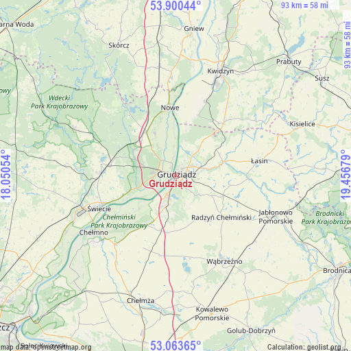
Grudziądz GPS coordinates[2]
53° 29' 2.796" North, 18° 45' 13.176" East
| Map corner | latitude | longitude |
|---|---|---|
| Upper-left | 53.90044°, | 18.05054° |
| Center: | 53.48411°, | 18.75366° |
| Lower-right: | 53.06365°, | 19.45679° |
| Map W x H: | 93×93 km | = 57.8×57.8mi |
| max Lat: | 54.83135° ⇑10.7% North |
| Grudziądz: | 53.48411° |
| min Lat: | ⇓89.3% South 49.21328° |
| min Long | Grudziądz | max Long |
| 14.20249° | 18.75366° | 24.03723° |
| W 35.7%⇐ | ⇒64.3% E |
Elevation
Elevation of Grudziądz is 22 m = 72 ft, and this is 169.4 m = 556 ft below average elevation for this country.
| Max E: |
974 m = 3196 ft | 96.9% |
| Avg. | 191.4 m = 628 ft | |
| Grudziądz | 22 m = 72 ft | |
Min E: |
-3 m = -10 ft | 3.1% |
See also: Grudziądz elevation on elevation.city.
Geographical zone
Grudziądz is located in North temperate zone (between Tropic of Cancer and the Arctic Circle). Distance of this North polar circle is 1454.3 km =903.7 mi to North.| Distance of | km | miles | from Grudziądz |
|---|---|---|---|
| North Pole | 4060.2 | 2522.9 | to North |
| Arctic Circle | 1454.3 | 903.7 | to North |
| Tropic Cancer | 3341 | 2076 | to South |
| Equator | 5946.9 | 3695.2 | to South |


Nearby cities:
15 places around Grudziądz: (largest is in red/bold)
• Dragasz
2.6 km =1.6 mi,  338°
338°
• Gardeja
19 km =11.8 mi,  42°
42°
• Gruta
13.9 km =8.6 mi,  104°
104°
• Jeżewo
17.4 km =10.8 mi,  279°
279°
• Lisewo
21.4 km =13.3 mi,  191°
191°
• Nowe
18.4 km =11.4 mi,  354°
354°
• Płużnica
20.9 km =13 mi,  175°
175°
• Radzyń Chełmiński
16.4 km =10.2 mi,  132°
132°
• Rogóźno
12.9 km =8 mi,  63°
63°
• Sadlinki
21.5 km =13.4 mi,  20°
20°
• Stolno
24.5 km =15.2 mi,  222°
222°
• Warlubie
13.9 km =8.6 mi,  325°
325°
• Łasin
22.5 km =14 mi,  80°
80°
• Świecie
21.9 km =13.6 mi,  247°
247°
• Świecie nad Osą
23.5 km =14.6 mi, 100°
Sources, notices
• [Note1] Compared only with cities in Poland existing in our database
• [Src1] Map data: © OpenStreetMap contributors (CC-BY-SA)
• [Src2] Other city data from geonames.org with taken over terms of usage.
• [Src3] Geographical zone / Annual Mean Temperature by Robert A. Rohde @ Wikipedia
