Kwidzyn geodata
Kwidzyn (Pomerania) is a seat of a third-order administrative division; located in Poland in Europe/Warsaw (GMT+2) time zone. With population of 37,601 people, there are 140 cities with bigger population in this country. Compared to other cities in Poland, 91.6% of cities are located further ↓South; 61.3% of cities are located further →East and 92.1% of cities have higher elevation than Kwidzyn. Note1


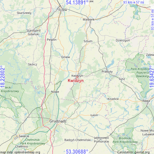
Kwidzyn GPS coordinates[2]
53° 43' 29.82" North, 18° 55' 52.104" East
| Map corner | latitude | longitude |
|---|---|---|
| Upper-left | 54.13891°, | 18.22802° |
| Center: | 53.72495°, | 18.93114° |
| Lower-right: | 53.30688°, | 19.63427° |
| Map W x H: | 92.5×92.5 km | = 57.5×57.5mi |
| max Lat: | 54.83135° ⇑8.4% North |
| Kwidzyn: | 53.72495° |
| min Lat: | ⇓91.6% South 49.21328° |
| min Long | Kwidzyn | max Long |
| 14.20249° | 18.93114° | 24.03723° |
| W 38.7%⇐ | ⇒61.3% E |
Elevation
Elevation of Kwidzyn is 64 m = 210 ft, and this is 127.4 m = 418 ft below average elevation for this country.
| Max E: |
974 m = 3196 ft | 92.1% |
| Avg. | 191.4 m = 628 ft | |
| Kwidzyn | 64 m = 210 ft | |
Min E: |
-3 m = -10 ft | 7.9% |
See also: Poland elevation on elevation.city.
Geographical zone
Kwidzyn is located in North temperate zone (between Tropic of Cancer and the Arctic Circle). Distance of this North polar circle is 1427.5 km =887 mi to North.| Distance of | km | miles | from Kwidzyn |
|---|---|---|---|
| North Pole | 4033.4 | 2506.2 | to North |
| Arctic Circle | 1427.5 | 887 | to North |
| Tropic Cancer | 3367.7 | 2092.6 | to South |
| Equator | 5973.7 | 3711.9 | to South |


Nearby cities:
15 places around Kwidzyn: (largest is in red/bold)
• Gardeja
12.7 km =7.9 mi,  175°
175°
• Gniew
14.2 km =8.8 mi,  330°
330°
• Kopytkowo
18.6 km =11.6 mi,  274°
274°
• Mikołajki Pomorskie
20.9 km =13 mi,  47°
47°
• Morzeszczyn
20.3 km =12.6 mi,  309°
309°
• Nowe
15.9 km =9.9 mi,  237°
237°
• Prabuty
18.3 km =11.4 mi,  79°
79°
• Rogóźno
21 km =13 mi, 180°
• Ryjewo
13.4 km =8.3 mi,  8°
8°
• Sadlinki
7.8 km =4.8 mi,  212°
212°
• Smętowo Graniczne
16.3 km =10.1 mi,  278°
278°
• Sztum
22.7 km =14.1 mi,  16°
16°
• Warlubie
24.8 km =15.4 mi,  231°
231°
• Wielkie Walichnowy
21.9 km =13.6 mi,  346°
346°
• Łasin
25.2 km =15.7 mi,  155°
155°
Sources, notices
• [Note1] Compared only with cities in Poland existing in our database
• [Src1] Map data: © OpenStreetMap contributors (CC-BY-SA)
• [Src2] Other city data from geonames.org with taken over terms of usage.
• [Src3] Geographical zone / Annual Mean Temperature by Robert A. Rohde @ Wikipedia
