Chrzanów geodata
Chrzanów (Lesser Poland) is a populated place; located in Poland in Europe/Warsaw (GMT+2) time zone. With population of 39,973 people, there are 128 cities with bigger population in this country. Compared to other cities in Poland, 76.6% of cities are located further ↑North; 52.6% of cities are located further →East and 81.4% of cities have lower elevation than Chrzanów. Note1


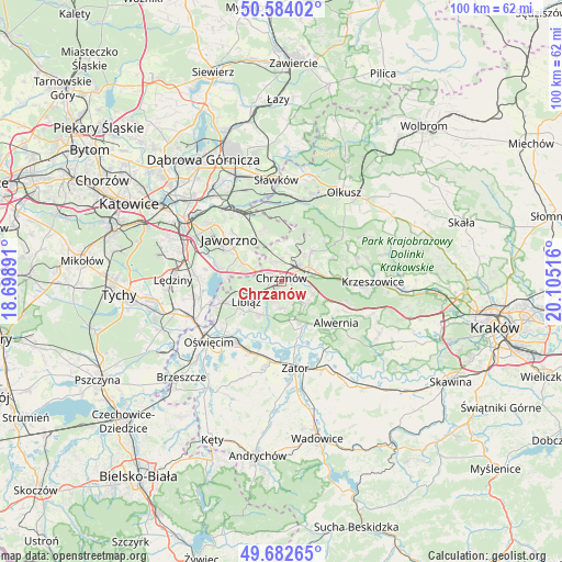
Chrzanów GPS coordinates[2]
50° 8' 7.656" North, 19° 24' 7.308" East
| Map corner | latitude | longitude |
|---|---|---|
| Upper-left | 50.58402°, | 18.69891° |
| Center: | 50.13546°, | 19.40203° |
| Lower-right: | 49.68265°, | 20.10516° |
| Map W x H: | 100.2×100.2 km | = 62.3×62.3mi |
| max Lat: | 54.83135° ⇑76.6% North |
| Chrzanów: | 50.13546° |
| min Lat: | ⇓23.4% South 49.21328° |
| min Long | Chrzanów | max Long |
| 14.20249° | 19.40203° | 24.03723° |
| W 47.4%⇐ | ⇒52.6% E |
Elevation
Elevation of Chrzanów is 273 m = 896 ft, and this is 81.6 m = 268 ft above average elevation for this country.
| Max E: |
974 m = 3196 ft | 18.6% |
| Chrzanów | 273 m 896 ft | |
| Avg. | 191.4 m = 628 ft | |
Min E: |
-3 m = -10 ft | 81.4% |
See also: Poland elevation on elevation.city.
Geographical zone
Chrzanów is located in North temperate zone (between Tropic of Cancer and the Arctic Circle). Distance of this North polar circle is 1826.6 km =1135 mi to North.| Distance of | km | miles | from Chrzanów |
|---|---|---|---|
| North Pole | 4432.5 | 2754.2 | to North |
| Arctic Circle | 1826.6 | 1135 | to North |
| Tropic Cancer | 2968.6 | 1844.6 | to South |
| Equator | 5574.5 | 3463.8 | to South |


Nearby cities:
15 places around Chrzanów: (largest is in red/bold)
• Babice
8.1 km =5 mi,  155°
155°
• Balin
3.9 km =2.4 mi,  339°
339°
• Bolęcin
6 km =3.7 mi,  109°
109°
• Libiąż
7.1 km =4.4 mi,  240°
240°
• Luszowice
4.3 km =2.7 mi,  2°
2°
• Myślachowice
7.9 km =4.9 mi,  45°
45°
• Mętków
9.4 km =5.8 mi,  191°
191°
• Olszyny
9.8 km =6.1 mi, 158°
• Piła Kościelecka
4.4 km =2.7 mi,  95°
95°
• Pogorzyce
4 km =2.5 mi, 158°
• Psary
10 km =6.2 mi,  65°
65°
• Płaza
6 km =3.7 mi,  131°
131°
• Trzebinia
5.5 km =3.4 mi,  61°
61°
• Zagórze
4.6 km =2.9 mi,  178°
178°
• Żarki
6.9 km =4.3 mi,  211°
211°
Sources, notices
• [Note1] Compared only with cities in Poland existing in our database
• [Src1] Map data: © OpenStreetMap contributors (CC-BY-SA)
• [Src2] Other city data from geonames.org with taken over terms of usage.
• [Src3] Geographical zone / Annual Mean Temperature by Robert A. Rohde @ Wikipedia
