Pogorzyce geodata
Pogorzyce (Lesser Poland) is a populated place; located in Poland in Europe/Warsaw (GMT+2) time zone. With population of 1,400 people, there are 1959 cities with bigger population in this country. Compared to other cities in Poland, 77.8% of cities are located further ↑North; 52.3% of cities are located further →East and 92.1% of cities have lower elevation than Pogorzyce. Note1


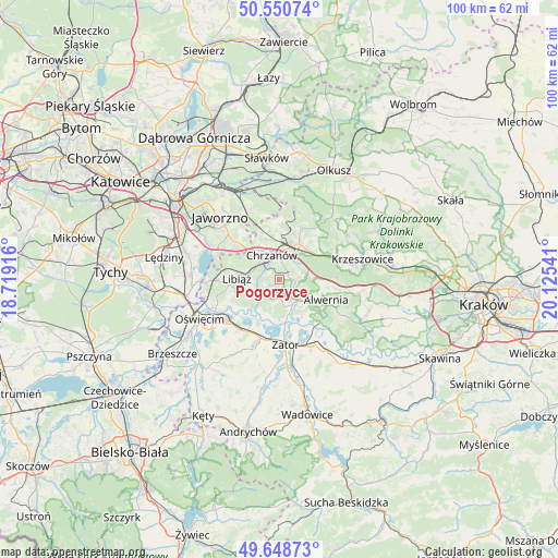
Pogorzyce GPS coordinates[2]
50° 6' 6.696" North, 19° 25' 20.208" East
| Map corner | latitude | longitude |
|---|---|---|
| Upper-left | 50.55074°, | 18.71916° |
| Center: | 50.10186°, | 19.42228° |
| Lower-right: | 49.64873°, | 20.12541° |
| Map W x H: | 100.3×100.3 km | = 62.3×62.3mi |
| max Lat: | 54.83135° ⇑77.8% North |
| Pogorzyce: | 50.10186° |
| min Lat: | ⇓22.2% South 49.21328° |
| min Long | Pogorzyce | max Long |
| 14.20249° | 19.42228° | 24.03723° |
| W 47.7%⇐ | ⇒52.3% E |
Elevation
Elevation of Pogorzyce is 358 m = 1175 ft, and this is 166.6 m = 547 ft above average elevation for this country.
| Max E: |
974 m = 3196 ft | 7.9% |
| Pogorzyce | 358 m 1175 ft | |
| Avg. | 191.4 m = 628 ft | |
Min E: |
-3 m = -10 ft | 92.1% |
See also: Poland elevation on elevation.city.
Geographical zone
Pogorzyce is located in North temperate zone (between Tropic of Cancer and the Arctic Circle). Distance of this North polar circle is 1830.4 km =1137.4 mi to North.| Distance of | km | miles | from Pogorzyce |
|---|---|---|---|
| North Pole | 4436.3 | 2756.6 | to North |
| Arctic Circle | 1830.4 | 1137.4 | to North |
| Tropic Cancer | 2964.9 | 1842.3 | to South |
| Equator | 5570.8 | 3461.5 | to South |


Nearby cities:
15 places around Pogorzyce: (largest is in red/bold)
• Babice
4.1 km =2.5 mi,  152°
152°
• Balin
7.9 km =4.9 mi,  339°
339°
• Bolęcin
4.5 km =2.8 mi,  67°
67°
• Chrzanów
4 km =2.5 mi, 338°
• Jankowice
6.6 km =4.1 mi,  167°
167°
• Kwaczała
6.5 km =4 mi,  130°
130°
• Libiąż
7.6 km =4.7 mi,  271°
271°
• Mętków
6.4 km =4 mi,  211°
211°
• Olszyny
5.8 km =3.6 mi,  158°
158°
• Piła Kościelecka
4.4 km =2.7 mi,  41°
41°
• Płaza
3 km =1.9 mi,  94°
94°
• Regulice
7.8 km =4.8 mi,  105°
105°
• Trzebinia
7.2 km =4.5 mi,  27°
27°
• Zagórze
1.6 km =1 mi,  238°
238°
• Żarki
5.5 km =3.4 mi,  246°
246°
Sources, notices
• [Note1] Compared only with cities in Poland existing in our database
• [Src1] Map data: © OpenStreetMap contributors (CC-BY-SA)
• [Src2] Other city data from geonames.org with taken over terms of usage.
• [Src3] Geographical zone / Annual Mean Temperature by Robert A. Rohde @ Wikipedia
