Balin geodata
Balin (Lesser Poland) is a section of populated place; located in Poland in Europe/Warsaw (GMT+2) time zone. With population of 3,400 people, there are 934 cities with bigger population in this country. Compared to other cities in Poland, 75.3% of cities are located further ↑North; 53% of cities are located further →East and 88.8% of cities have lower elevation than Balin. Note1


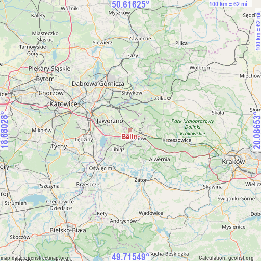
Balin GPS coordinates[2]
50° 10' 4.764" North, 19° 23' 0.24" East
| Map corner | latitude | longitude |
|---|---|---|
| Upper-left | 50.61625°, | 18.68028° |
| Center: | 50.16799°, | 19.3834° |
| Lower-right: | 49.71549°, | 20.08653° |
| Map W x H: | 100.2×100.2 km | = 62.3×62.3mi |
| max Lat: | 54.83135° ⇑75.3% North |
| Balin: | 50.16799° |
| min Lat: | ⇓24.7% South 49.21328° |
| min Long | Balin | max Long |
| 14.20249° | 19.3834° | 24.03723° |
| W 47%⇐ | ⇒53% E |
Elevation
Elevation of Balin is 315 m = 1033 ft, and this is 123.6 m = 406 ft above average elevation for this country.
| Max E: |
974 m = 3196 ft | 11.2% |
| Balin | 315 m 1033 ft | |
| Avg. | 191.4 m = 628 ft | |
Min E: |
-3 m = -10 ft | 88.8% |
See also: Poland elevation on elevation.city.
Geographical zone
Balin is located in North temperate zone (between Tropic of Cancer and the Arctic Circle). Distance of this North polar circle is 1823 km =1132.8 mi to North.| Distance of | km | miles | from Balin |
|---|---|---|---|
| North Pole | 4428.9 | 2752 | to North |
| Arctic Circle | 1823 | 1132.8 | to North |
| Tropic Cancer | 2972.2 | 1846.8 | to South |
| Equator | 5578.2 | 3466.1 | to South |


Nearby cities:
15 places around Balin: (largest is in red/bold)
• Bolęcin
8.9 km =5.5 mi,  128°
128°
• Bukowno
12 km =7.5 mi,  26°
26°
• Chrzanów
3.9 km =2.4 mi,  159°
159°
• Jaworzno
8.8 km =5.5 mi,  298°
298°
• Libiąż
8.6 km =5.3 mi,  214°
214°
• Luszowice
1.6 km =1 mi,  65°
65°
• Myślachowice
7.2 km =4.5 mi, 74°
• Piła Kościelecka
6.9 km =4.3 mi, 125°
• Pogorzyce
7.9 km =4.9 mi, 159°
• Psary
10.4 km =6.5 mi,  87°
87°
• Płaza
9.5 km =5.9 mi,  142°
142°
• Płoki
10.3 km =6.4 mi, 65°
• Trzebinia
6.2 km =3.9 mi,  98°
98°
• Zagórze
8.3 km =5.2 mi,  170°
170°
• Żarki
9.8 km =6.1 mi,  193°
193°
Sources, notices
• [Note1] Compared only with cities in Poland existing in our database
• [Src1] Map data: © OpenStreetMap contributors (CC-BY-SA)
• [Src2] Other city data from geonames.org with taken over terms of usage.
• [Src3] Geographical zone / Annual Mean Temperature by Robert A. Rohde @ Wikipedia
