Toporzysko geodata
Toporzysko (Lesser Poland) is a populated place; located in Poland in Europe/Warsaw (GMT+2) time zone. With population of 1,833 people, there are 1588 cities with bigger population in this country. Compared to other cities in Poland, 96.1% of cities are located further ↑North; 55% of cities are located further ←West and 97.2% of cities have lower elevation than Toporzysko. Note1


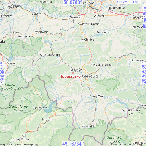
Toporzysko GPS coordinates[2]
49° 37' 29.82" North, 19° 48' 8.136" East
| Map corner | latitude | longitude |
|---|---|---|
| Upper-left | 50.0783°, | 19.09914° |
| Center: | 49.62495°, | 19.80226° |
| Lower-right: | 49.16734°, | 20.50539° |
| Map W x H: | 101.3×101.3 km | = 62.9×62.9mi |
| max Lat: | 54.83135° ⇑96.1% North |
| Toporzysko: | 49.62495° |
| min Lat: | ⇓3.9% South 49.21328° |
| min Long | Toporzysko | max Long |
| 14.20249° | 19.80226° | 24.03723° |
| W 55%⇐ | ⇒45% E |
Elevation
Elevation of Toporzysko is 484 m = 1588 ft, and this is 292.6 m = 960 ft above average elevation for this country.
| Max E: |
974 m = 3196 ft | 2.8% |
| Toporzysko | 484 m 1588 ft | |
| Avg. | 191.4 m = 628 ft | |
Min E: |
-3 m = -10 ft | 97.2% |
See also: Poland elevation on elevation.city.
Geographical zone
Toporzysko is located in North temperate zone (between Tropic of Cancer and the Arctic Circle). Distance of this North polar circle is 1883.4 km =1170.3 mi to North.| Distance of | km | miles | from Toporzysko |
|---|---|---|---|
| North Pole | 4489.3 | 2789.5 | to North |
| Arctic Circle | 1883.4 | 1170.3 | to North |
| Tropic Cancer | 2911.9 | 1809.4 | to South |
| Equator | 5517.8 | 3428.6 | to South |


Nearby cities:
15 places around Toporzysko: (largest is in red/bold)
• Bystra
3 km =1.9 mi,  327°
327°
• Harkabuz
9.9 km =6.2 mi,  166°
166°
• Jordanów
3.4 km =2.1 mi,  36°
36°
• Juszczyn
11 km =6.8 mi,  313°
313°
• Naprawa
6 km =3.7 mi,  66°
66°
• Osielec
6.4 km =4 mi,  347°
347°
• Podsarnie
8.1 km =5 mi,  186°
186°
• Podwilk
9.7 km =6 mi,  208°
208°
• Raba Wyżna
8.5 km =5.3 mi,  139°
139°
• Rokiciny
10.5 km =6.5 mi,  123°
123°
• Sidzina
7.5 km =4.7 mi,  240°
240°
• Skomielna Czarna
11.6 km =7.2 mi,  12°
12°
• Spytkowice
5.7 km =3.5 mi,  156°
156°
• Wysoka
3.4 km =2.1 mi,  100°
100°
• Łętownia
9.5 km =5.9 mi,  31°
31°
Sources, notices
• [Note1] Compared only with cities in Poland existing in our database
• [Src1] Map data: © OpenStreetMap contributors (CC-BY-SA)
• [Src2] Other city data from geonames.org with taken over terms of usage.
• [Src3] Geographical zone / Annual Mean Temperature by Robert A. Rohde @ Wikipedia
