Naprawa geodata
Naprawa (Lesser Poland) is a populated place; located in Poland in Europe/Warsaw (GMT+2) time zone. With population of 2,100 people, there are 1411 cities with bigger population in this country. Compared to other cities in Poland, 95.8% of cities are located further ↑North; 56.5% of cities are located further ←West and 98% of cities have lower elevation than Naprawa. Note1


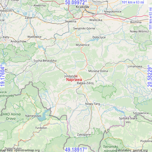
Naprawa GPS coordinates[2]
49° 38' 47.652" North, 19° 52' 44.976" East
| Map corner | latitude | longitude |
|---|---|---|
| Upper-left | 50.09972°, | 19.17604° |
| Center: | 49.64657°, | 19.87916° |
| Lower-right: | 49.18917°, | 20.58229° |
| Map W x H: | 101.2×101.2 km | = 62.9×62.9mi |
| max Lat: | 54.83135° ⇑95.8% North |
| Naprawa: | 49.64657° |
| min Lat: | ⇓4.2% South 49.21328° |
| min Long | Naprawa | max Long |
| 14.20249° | 19.87916° | 24.03723° |
| W 56.5%⇐ | ⇒43.5% E |
Elevation
Elevation of Naprawa is 534 m = 1752 ft, and this is 342.6 m = 1124 ft above average elevation for this country.
| Max E: |
974 m = 3196 ft | 2% |
| Naprawa | 534 m 1752 ft | |
| Avg. | 191.4 m = 628 ft | |
Min E: |
-3 m = -10 ft | 98% |
See also: Poland elevation on elevation.city.
Geographical zone
Naprawa is located in North temperate zone (between Tropic of Cancer and the Arctic Circle). Distance of this North polar circle is 1881 km =1168.8 mi to North.| Distance of | km | miles | from Naprawa |
|---|---|---|---|
| North Pole | 4486.9 | 2788 | to North |
| Arctic Circle | 1881 | 1168.8 | to North |
| Tropic Cancer | 2914.3 | 1810.9 | to South |
| Equator | 5520.2 | 3430.1 | to South |


Nearby cities:
15 places around Naprawa: (largest is in red/bold)
• Bystra
7.1 km =4.4 mi,  271°
271°
• Jordanów
3.6 km =2.2 mi, 274°
• Krzczonów
10.6 km =6.6 mi,  15°
15°
• Lubień
10.8 km =6.7 mi,  41°
41°
• Olszówka
11.4 km =7.1 mi,  108°
108°
• Osielec
7.9 km =4.9 mi,  298°
298°
• Raba Wyżna
8.9 km =5.5 mi,  179°
179°
• Rabka-Zdrój
7.6 km =4.7 mi,  123°
123°
• Rokiciny
8.8 km =5.5 mi,  159°
159°
• Skomielna Czarna
9.5 km =5.9 mi,  341°
341°
• Spytkowice
8.4 km =5.2 mi,  203°
203°
• Tokarnia
9 km =5.6 mi,  356°
356°
• Toporzysko
6 km =3.7 mi,  246°
246°
• Wysoka
3.7 km =2.3 mi,  216°
216°
• Łętownia
5.7 km =3.5 mi,  354°
354°
Sources, notices
• [Note1] Compared only with cities in Poland existing in our database
• [Src1] Map data: © OpenStreetMap contributors (CC-BY-SA)
• [Src2] Other city data from geonames.org with taken over terms of usage.
• [Src3] Geographical zone / Annual Mean Temperature by Robert A. Rohde @ Wikipedia
