Łętownia geodata
Łętownia (Lesser Poland) is a populated place; located in Poland in Europe/Warsaw (GMT+2) time zone. With population of 2,800 people, there are 1120 cities with bigger population in this country. Compared to other cities in Poland, 94.5% of cities are located further ↑North; 56.3% of cities are located further ←West and 96.9% of cities have lower elevation than Łętownia. Note1


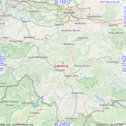
Łętownia GPS coordinates[2]
49° 41' 50.82" North, 19° 52' 15.924" East
| Map corner | latitude | longitude |
|---|---|---|
| Upper-left | 50.15012°, | 19.16797° |
| Center: | 49.69745°, | 19.87109° |
| Lower-right: | 49.24052°, | 20.57422° |
| Map W x H: | 101.1×101.1 km | = 62.8×62.8mi |
| max Lat: | 54.83135° ⇑94.5% North |
| Łętownia: | 49.69745° |
| min Lat: | ⇓5.5% South 49.21328° |
| min Long | Łętownia | max Long |
| 14.20249° | 19.87109° | 24.03723° |
| W 56.3%⇐ | ⇒43.7% E |
Elevation
Elevation of Łętownia is 467 m = 1532 ft, and this is 275.6 m = 904 ft above average elevation for this country.
| Max E: |
974 m = 3196 ft | 3.1% |
| Łętownia | 467 m 1532 ft | |
| Avg. | 191.4 m = 628 ft | |
Min E: |
-3 m = -10 ft | 96.9% |
See also: Poland elevation on elevation.city.
Geographical zone
Łętownia is located in North temperate zone (between Tropic of Cancer and the Arctic Circle). Distance of this North polar circle is 1875.3 km =1165.3 mi to North.| Distance of | km | miles | from Łętownia |
|---|---|---|---|
| North Pole | 4481.2 | 2784.5 | to North |
| Arctic Circle | 1875.3 | 1165.3 | to North |
| Tropic Cancer | 2919.9 | 1814.3 | to South |
| Equator | 5525.8 | 3433.6 | to South |


Nearby cities:
15 places around Łętownia: (largest is in red/bold)
• Bieńkówka
11.3 km =7 mi,  320°
320°
• Bystra
8.6 km =5.3 mi,  230°
230°
• Jordanów
6.1 km =3.8 mi,  209°
209°
• Krzczonów
5.7 km =3.5 mi,  36°
36°
• Lubień
8.1 km =5 mi,  72°
72°
• Naprawa
5.7 km =3.5 mi,  174°
174°
• Osielec
6.6 km =4.1 mi,  253°
253°
• Pcim
9.4 km =5.8 mi,  50°
50°
• Rabka-Zdrój
12 km =7.5 mi,  145°
145°
• Skomielna Czarna
4.1 km =2.5 mi, 322°
• Stróża
11.6 km =7.2 mi,  19°
19°
• Tokarnia
3.3 km =2.1 mi,  0°
0°
• Toporzysko
9.5 km =5.9 mi, 211°
• Trzebunia
10.6 km =6.6 mi,  350°
350°
• Wysoka
8.8 km =5.5 mi,  190°
190°
Sources, notices
• [Note1] Compared only with cities in Poland existing in our database
• [Src1] Map data: © OpenStreetMap contributors (CC-BY-SA)
• [Src2] Other city data from geonames.org with taken over terms of usage.
• [Src3] Geographical zone / Annual Mean Temperature by Robert A. Rohde @ Wikipedia
