Bystra geodata
Bystra (Lesser Poland) is a populated place; located in Poland in Europe/Warsaw (GMT+2) time zone. With population of 2,900 people, there are 1090 cities with bigger population in this country. Compared to other cities in Poland, 95.7% of cities are located further ↑North; 54.4% of cities are located further ←West and 96% of cities have lower elevation than Bystra. Note1


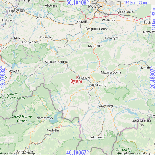
Bystra GPS coordinates[2]
49° 38' 52.656" North, 19° 46' 47.784" East
| Map corner | latitude | longitude |
|---|---|---|
| Upper-left | 50.10109°, | 19.07682° |
| Center: | 49.64796°, | 19.77994° |
| Lower-right: | 49.19057°, | 20.48307° |
| Map W x H: | 101.2×101.2 km | = 62.9×62.9mi |
| max Lat: | 54.83135° ⇑95.7% North |
| Bystra: | 49.64796° |
| min Lat: | ⇓4.3% South 49.21328° |
| min Long | Bystra | max Long |
| 14.20249° | 19.77994° | 24.03723° |
| W 54.4%⇐ | ⇒45.6% E |
Elevation
Elevation of Bystra is 446 m = 1463 ft, and this is 254.6 m = 835 ft above average elevation for this country.
| Max E: |
974 m = 3196 ft | 4% |
| Bystra | 446 m 1463 ft | |
| Avg. | 191.4 m = 628 ft | |
Min E: |
-3 m = -10 ft | 96% |
See also: Poland elevation on elevation.city.
Geographical zone
Bystra is located in North temperate zone (between Tropic of Cancer and the Arctic Circle). Distance of this North polar circle is 1880.8 km =1168.7 mi to North.| Distance of | km | miles | from Bystra |
|---|---|---|---|
| North Pole | 4486.7 | 2787.9 | to North |
| Arctic Circle | 1880.8 | 1168.7 | to North |
| Tropic Cancer | 2914.4 | 1810.9 | to South |
| Equator | 5520.3 | 3430.2 | to South |


Nearby cities:
15 places around Bystra: (largest is in red/bold)
• Białka
9.3 km =5.8 mi,  302°
302°
• Jordanów
3.6 km =2.2 mi,  87°
87°
• Juszczyn
8.1 km =5 mi,  308°
308°
• Naprawa
7.1 km =4.4 mi, 91°
• Osielec
3.7 km =2.3 mi,  2°
2°
• Podsarnie
10.6 km =6.6 mi,  175°
175°
• Podwilk
11.5 km =7.1 mi,  194°
194°
• Raba Wyżna
11.5 km =7.1 mi,  141°
141°
• Sidzina
8 km =5 mi,  218°
218°
• Skomielna Czarna
9.7 km =6 mi,  24°
24°
• Spytkowice
8.7 km =5.4 mi,  153°
153°
• Tokarnia
11 km =6.8 mi,  36°
36°
• Toporzysko
3 km =1.9 mi, 147°
• Wysoka
5.8 km =3.6 mi,  122°
122°
• Łętownia
8.6 km =5.3 mi,  50°
50°
Sources, notices
• [Note1] Compared only with cities in Poland existing in our database
• [Src1] Map data: © OpenStreetMap contributors (CC-BY-SA)
• [Src2] Other city data from geonames.org with taken over terms of usage.
• [Src3] Geographical zone / Annual Mean Temperature by Robert A. Rohde @ Wikipedia
