Szczodre geodata
Szczodre (Lower Silesia) is a populated place; located in Poland in Europe/Warsaw (GMT+2) time zone. With population of 713 people, there are 3044 cities with bigger population in this country. Compared to other cities in Poland, 50.8% of cities are located further ↓South; 82.3% of cities are located further →East and 65.6% of cities have higher elevation than Szczodre. Note1


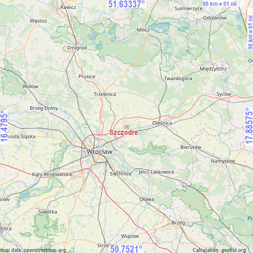
Szczodre GPS coordinates[2]
51° 11' 41.424" North, 17° 10' 57.432" East
| Map corner | latitude | longitude |
|---|---|---|
| Upper-left | 51.63337°, | 16.4795° |
| Center: | 51.19484°, | 17.18262° |
| Lower-right: | 50.7521°, | 17.88575° |
| Map W x H: | 98×98 km | = 60.9×60.9mi |
| max Lat: | 54.83135° ⇑49.2% North |
| Szczodre: | 51.19484° |
| min Lat: | ⇓50.8% South 49.21328° |
| min Long | Szczodre | max Long |
| 14.20249° | 17.18262° | 24.03723° |
| W 17.7%⇐ | ⇒82.3% E |
Elevation
Elevation of Szczodre is 131 m = 430 ft, and this is 60.4 m = 198 ft below average elevation for this country.
| Max E: |
974 m = 3196 ft | 65.6% |
| Avg. | 191.4 m = 628 ft | |
| Szczodre | 131 m = 430 ft | |
Min E: |
-3 m = -10 ft | 34.4% |
See also: Poland elevation on elevation.city.
Geographical zone
Szczodre is located in North temperate zone (between Tropic of Cancer and the Arctic Circle). Distance of this North polar circle is 1708.8 km =1061.8 mi to North.| Distance of | km | miles | from Szczodre |
|---|---|---|---|
| North Pole | 4314.7 | 2681 | to North |
| Arctic Circle | 1708.8 | 1061.8 | to North |
| Tropic Cancer | 3086.4 | 1917.8 | to South |
| Equator | 5692.3 | 3537 | to South |


Nearby cities:
15 places around Szczodre: (largest is in red/bold)
• Długołęka
1.9 km =1.2 mi,  160°
160°
• Kiełczów
6.1 km =3.8 mi,  183°
183°
• Kowale-Popiele
9.1 km =5.7 mi,  218°
218°
• Mirków
3.9 km =2.4 mi,  192°
192°
• Pawłowice-Kłokoczyce
6.8 km =4.2 mi,  240°
240°
• Psie Pole Południe-Kiełczów
6.5 km =4 mi, 216°
• Psie Pole Północ
6.9 km =4.3 mi,  227°
227°
• Rejon alei Kromera
10.3 km =6.4 mi, 228°
• Sołtysowice
9.1 km =5.7 mi, 239°
• Strachocin-Wojnów
10.2 km =6.3 mi, 192°
• Swojczyce
9.7 km =6 mi,  204°
204°
• Wilczyce
7.5 km =4.7 mi, 194°
• Zakrzów
4.5 km =2.8 mi, 225°
• Zalesie i Stadion
10.5 km =6.5 mi, 217°
• Zgorzelisko
7.2 km =4.5 mi,  208°
208°
Sources, notices
• [Note1] Compared only with cities in Poland existing in our database
• [Src1] Map data: © OpenStreetMap contributors (CC-BY-SA)
• [Src2] Other city data from geonames.org with taken over terms of usage.
• [Src3] Geographical zone / Annual Mean Temperature by Robert A. Rohde @ Wikipedia
