Psie Pole Południe-Kiełczów geodata
Psie Pole Południe-Kiełczów (Lower Silesia) is a section of populated place; located in Poland in Europe/Warsaw (GMT+2) time zone. With population of 5,263 people, there are 659 cities with bigger population in this country. Compared to other cities in Poland, 50.4% of cities are located further ↑North; 82.9% of cities are located further →East and 66.1% of cities have higher elevation than Psie Pole Południe-Kiełczów. Note1
Administrative division(s):
- Level 1: Lower Silesia
- Level 2: Wrocław
- Level 3: Wrocław
- Level 4: Psie Pole - Zawidawie
Current local time in Psie Pole Południe-Kiełczów:
04:04 AM, SaturdayDifference from your time zone: hours


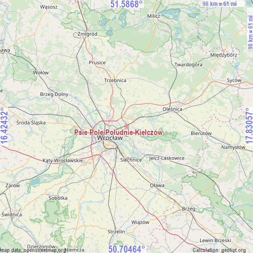
Psie Pole Południe-Kiełczów GPS coordinates[2]
51° 8' 52.188" North, 17° 7' 38.784" East
| Map corner | latitude | longitude |
|---|---|---|
| Upper-left | 51.5868°, | 16.42432° |
| Center: | 51.14783°, | 17.12744° |
| Lower-right: | 50.70464°, | 17.83057° |
| Map W x H: | 98.1×98.1 km | = 61×61mi |
| max Lat: | 54.83135° ⇑50.4% North |
| Psie Pole Południe-Kiełczów: | 51.14783° |
| min Lat: | ⇓49.6% South 49.21328° |
| min Long | Psie Pole Połu | max Long |
| 14.20249° | 17.12744° | 24.03723° |
| W 17.1%⇐ | ⇒82.9% E |
Elevation
Elevation of Psie Pole Południe-Kiełczów is 130 m = 427 ft, and this is 61.4 m = 201 ft below average elevation for this country.
| Max E: |
974 m = 3196 ft | 66.1% |
| Avg. | 191.4 m = 628 ft | |
| Psie Pole Południe-Kiełczów | 130 m = 427 ft | |
Min E: |
-3 m = -10 ft | 33.9% |
See also: Poland elevation on elevation.city.
Geographical zone
Psie Pole Południe-Kiełczów is located in North temperate zone (between Tropic of Cancer and the Arctic Circle). Distance of this North polar circle is 1714.1 km =1065.1 mi to North.| Distance of | km | miles | from Psie Pole Południe-Kiełczów |
|---|---|---|---|
| North Pole | 4320 | 2684.3 | to North |
| Arctic Circle | 1714.1 | 1065.1 | to North |
| Tropic Cancer | 3081.2 | 1914.6 | to South |
| Equator | 5687.1 | 3533.8 | to South |


Nearby cities:
15 places around Psie Pole Południe-Kiełczów: (largest is in red/bold)
• Kiełczów
3.6 km =2.2 mi,  103°
103°
• Kowale-Popiele
2.6 km =1.6 mi,  223°
223°
• Mirków
3.3 km =2.1 mi,  63°
63°
• Pawłowice-Kłokoczyce
2.8 km =1.7 mi,  313°
313°
• Psie Pole Północ
1.4 km =0.9 mi,  294°
294°
• Rejon alei Kromera
4.2 km =2.6 mi,  248°
248°
• Sołtysowice
4 km =2.5 mi,  278°
278°
• Strachocin-Wojnów
5 km =3.1 mi,  161°
161°
• Swojczyce
3.6 km =2.2 mi,  182°
182°
• Sępolno
4.6 km =2.9 mi,  202°
202°
• Wilczyce
2.8 km =1.7 mi,  137°
137°
• Zacisze
4.6 km =2.9 mi,  233°
233°
• Zakrzów
2.2 km =1.4 mi,  17°
17°
• Zalesie i Stadion
4 km =2.5 mi, 218°
• Zgorzelisko
1.1 km =0.7 mi, 157°
Sources, notices
• [Note1] Compared only with cities in Poland existing in our database
• [Src1] Map data: © OpenStreetMap contributors (CC-BY-SA)
• [Src2] Other city data from geonames.org with taken over terms of usage.
• [Src3] Geographical zone / Annual Mean Temperature by Robert A. Rohde @ Wikipedia
