Zgorzelisko geodata
Zgorzelisko (Lower Silesia) is a section of populated place; located in Poland in Europe/Warsaw (GMT+2) time zone. With population of 11,967 people, there are 397 cities with bigger population in this country. Compared to other cities in Poland, 51.1% of cities are located further ↑North; 82.8% of cities are located further →East and 70.4% of cities have higher elevation than Zgorzelisko. Note1
Administrative division(s):
- Level 1: Lower Silesia
- Level 2: Wrocław
- Level 3: Wrocław
- Level 4: Psie Pole - Zawidawie


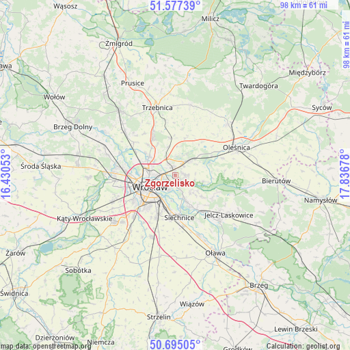
Zgorzelisko GPS coordinates[2]
51° 8' 17.988" North, 17° 8' 1.14" East
| Map corner | latitude | longitude |
|---|---|---|
| Upper-left | 51.57739°, | 16.43053° |
| Center: | 51.13833°, | 17.13365° |
| Lower-right: | 50.69505°, | 17.83678° |
| Map W x H: | 98.1×98.1 km | = 61×61mi |
| max Lat: | 54.83135° ⇑51.1% North |
| Zgorzelisko: | 51.13833° |
| min Lat: | ⇓48.9% South 49.21328° |
| min Long | Zgorzelisko | max Long |
| 14.20249° | 17.13365° | 24.03723° |
| W 17.2%⇐ | ⇒82.8% E |
Elevation
Elevation of Zgorzelisko is 120 m = 394 ft, and this is 71.4 m = 234 ft below average elevation for this country.
| Max E: |
974 m = 3196 ft | 70.4% |
| Avg. | 191.4 m = 628 ft | |
| Zgorzelisko | 120 m = 394 ft | |
Min E: |
-3 m = -10 ft | 29.6% |
See also: Poland elevation on elevation.city.
Geographical zone
Zgorzelisko is located in North temperate zone (between Tropic of Cancer and the Arctic Circle). Distance of this North polar circle is 1715.1 km =1065.7 mi to North.| Distance of | km | miles | from Zgorzelisko |
|---|---|---|---|
| North Pole | 4321 | 2684.9 | to North |
| Arctic Circle | 1715.1 | 1065.7 | to North |
| Tropic Cancer | 3080.1 | 1913.9 | to South |
| Equator | 5686 | 3533.1 | to South |


Nearby cities:
15 places around Zgorzelisko: (largest is in red/bold)
• Biskupin
4.6 km =2.9 mi,  206°
206°
• Kiełczów
3.1 km =1.9 mi,  86°
86°
• Kowale-Popiele
2.4 km =1.5 mi,  249°
249°
• Mirków
3.6 km =2.2 mi,  45°
45°
• Pawłowice-Kłokoczyce
3.9 km =2.4 mi,  320°
320°
• Psie Pole Południe-Kiełczów
1.1 km =0.7 mi,  337°
337°
• Psie Pole Północ
2.4 km =1.5 mi,  313°
313°
• Rejon alei Kromera
4.4 km =2.7 mi,  263°
263°
• Strachocin-Wojnów
3.9 km =2.4 mi,  162°
162°
• Swojczyce
2.6 km =1.6 mi,  192°
192°
• Sępolno
3.9 km =2.4 mi, 214°
• Wilczyce
1.8 km =1.1 mi,  123°
123°
• Zacisze
4.5 km =2.8 mi, 247°
• Zakrzów
3.1 km =1.9 mi,  4°
4°
• Zalesie i Stadion
3.6 km =2.2 mi,  234°
234°
Sources, notices
• [Note1] Compared only with cities in Poland existing in our database
• [Src1] Map data: © OpenStreetMap contributors (CC-BY-SA)
• [Src2] Other city data from geonames.org with taken over terms of usage.
• [Src3] Geographical zone / Annual Mean Temperature by Robert A. Rohde @ Wikipedia
