Zakrzów geodata
Zakrzów (Lower Silesia) is a section of populated place; located in Poland in Europe/Warsaw (GMT+2) time zone. With population of 10,737 people, there are 425 cities with bigger population in this country. Compared to other cities in Poland, 50.1% of cities are located further ↓South; 82.8% of cities are located further →East and 70.4% of cities have higher elevation than Zakrzów. Note1
Administrative division(s):
- Level 1: Lower Silesia
- Level 2: Wrocław
- Level 3: Wrocław
- Level 4: Psie Pole - Zawidawie


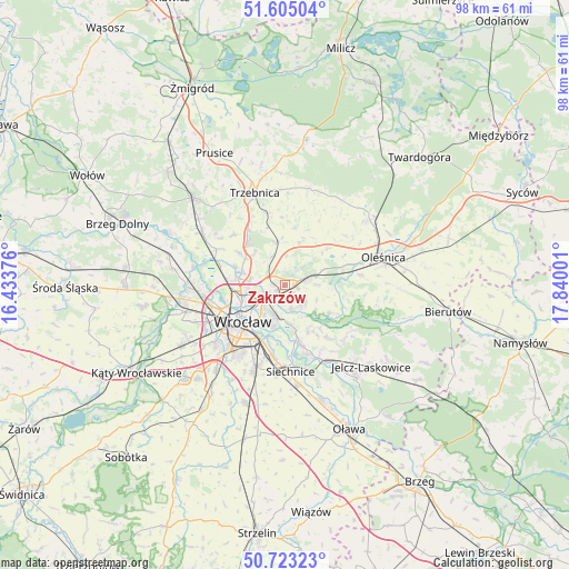
Zakrzów GPS coordinates[2]
51° 9' 58.464" North, 17° 8' 12.768" East
| Map corner | latitude | longitude |
|---|---|---|
| Upper-left | 51.60504°, | 16.43376° |
| Center: | 51.16624°, | 17.13688° |
| Lower-right: | 50.72323°, | 17.84001° |
| Map W x H: | 98×98 km | = 60.9×60.9mi |
| max Lat: | 54.83135° ⇑49.9% North |
| Zakrzów: | 51.16624° |
| min Lat: | ⇓50.1% South 49.21328° |
| min Long | Zakrzów | max Long |
| 14.20249° | 17.13688° | 24.03723° |
| W 17.2%⇐ | ⇒82.8% E |
Elevation
Elevation of Zakrzów is 120 m = 394 ft, and this is 71.4 m = 234 ft below average elevation for this country.
| Max E: |
974 m = 3196 ft | 70.4% |
| Avg. | 191.4 m = 628 ft | |
| Zakrzów | 120 m = 394 ft | |
Min E: |
-3 m = -10 ft | 29.6% |
See also: Poland elevation on elevation.city.
Geographical zone
Zakrzów is located in North temperate zone (between Tropic of Cancer and the Arctic Circle). Distance of this North polar circle is 1712 km =1063.8 mi to North.| Distance of | km | miles | from Zakrzów |
|---|---|---|---|
| North Pole | 4317.9 | 2683 | to North |
| Arctic Circle | 1712 | 1063.8 | to North |
| Tropic Cancer | 3083.2 | 1915.8 | to South |
| Equator | 5689.2 | 3535.1 | to South |


Nearby cities:
15 places around Zakrzów: (largest is in red/bold)
• Długołęka
4.1 km =2.5 mi,  69°
69°
• Kiełczów
4.1 km =2.5 mi,  135°
135°
• Kowale-Popiele
4.6 km =2.9 mi,  211°
211°
• Mirków
2.4 km =1.5 mi,  103°
103°
• Pawłowice-Kłokoczyce
2.7 km =1.7 mi,  266°
266°
• Psie Pole Południe-Kiełczów
2.2 km =1.4 mi,  197°
197°
• Psie Pole Północ
2.4 km =1.5 mi,  233°
233°
• Rejon alei Kromera
5.8 km =3.6 mi, 231°
• Sołtysowice
4.8 km =3 mi,  251°
251°
• Swojczyce
5.7 km =3.5 mi,  188°
188°
• Szczodre
4.5 km =2.8 mi,  45°
45°
• Wilczyce
4.3 km =2.7 mi,  163°
163°
• Zacisze
6.5 km =4 mi,  222°
222°
• Zalesie i Stadion
6.1 km =3.8 mi, 211°
• Zgorzelisko
3.1 km =1.9 mi,  184°
184°
Sources, notices
• [Note1] Compared only with cities in Poland existing in our database
• [Src1] Map data: © OpenStreetMap contributors (CC-BY-SA)
• [Src2] Other city data from geonames.org with taken over terms of usage.
• [Src3] Geographical zone / Annual Mean Temperature by Robert A. Rohde @ Wikipedia
