Szamocin geodata
Szamocin (Greater Poland) is a seat of a third-order administrative division; located in Poland in Europe/Warsaw (GMT+2) time zone. With population of 4,258 people, there are 770 cities with bigger population in this country. Compared to other cities in Poland, 83.9% of cities are located further ↓South; 82.9% of cities are located further →East and 88.9% of cities have higher elevation than Szamocin. Note1


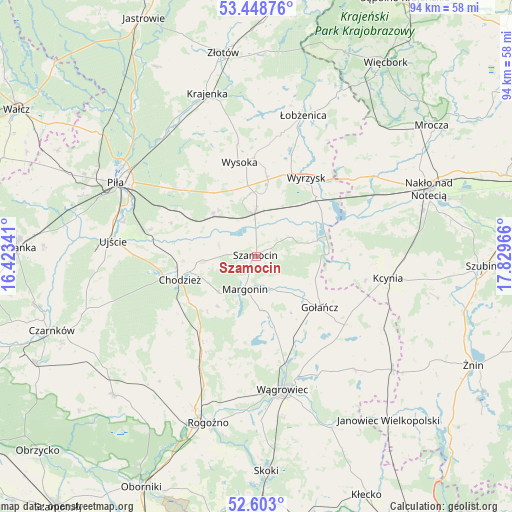
Szamocin GPS coordinates[2]
53° 1' 40.62" North, 17° 7' 35.508" East
| Map corner | latitude | longitude |
|---|---|---|
| Upper-left | 53.44876°, | 16.42341° |
| Center: | 53.02795°, | 17.12653° |
| Lower-right: | 52.603°, | 17.82966° |
| Map W x H: | 94×94 km | = 58.4×58.4mi |
| max Lat: | 54.83135° ⇑16.1% North |
| Szamocin: | 53.02795° |
| min Lat: | ⇓83.9% South 49.21328° |
| min Long | Szamocin | max Long |
| 14.20249° | 17.12653° | 24.03723° |
| W 17.1%⇐ | ⇒82.9% E |
Elevation
Elevation of Szamocin is 79 m = 259 ft, and this is 112.4 m = 369 ft below average elevation for this country.
| Max E: |
974 m = 3196 ft | 88.9% |
| Avg. | 191.4 m = 628 ft | |
| Szamocin | 79 m = 259 ft | |
Min E: |
-3 m = -10 ft | 11.1% |
See also: Poland elevation on elevation.city.
Geographical zone
Szamocin is located in North temperate zone (between Tropic of Cancer and the Arctic Circle). Distance of this North polar circle is 1505 km =935.2 mi to North.| Distance of | km | miles | from Szamocin |
|---|---|---|---|
| North Pole | 4110.9 | 2554.4 | to North |
| Arctic Circle | 1505 | 935.2 | to North |
| Tropic Cancer | 3290.2 | 2044.4 | to South |
| Equator | 5896.2 | 3663.7 | to South |


Nearby cities:
15 places around Szamocin: (largest is in red/bold)
• Białośliwie
8.5 km =5.3 mi,  359°
359°
• Budzyń
18 km =11.2 mi,  211°
211°
• Chodzież
14.3 km =8.9 mi,  255°
255°
• Gołańcz
14.9 km =9.3 mi,  129°
129°
• Kaczory
18.4 km =11.4 mi,  297°
297°
• Kcynia
24.5 km =15.2 mi,  99°
99°
• Margonin
6.4 km =4 mi,  199°
199°
• Miasteczko Krajeńskie
11.3 km =7 mi,  313°
313°
• Osiek nad Notecią
15 km =9.3 mi,  46°
46°
• Sadki
26.1 km =16.2 mi,  55°
55°
• Ujście
26.5 km =16.5 mi,  276°
276°
• Wyrzysk
16.8 km =10.4 mi,  34°
34°
• Wysoka
17.2 km =10.7 mi,  350°
350°
• Wągrowiec
24.9 km =15.5 mi,  168°
168°
• Śmiłowo
18.3 km =11.4 mi, 311°
Sources, notices
• [Note1] Compared only with cities in Poland existing in our database
• [Src1] Map data: © OpenStreetMap contributors (CC-BY-SA)
• [Src2] Other city data from geonames.org with taken over terms of usage.
• [Src3] Geographical zone / Annual Mean Temperature by Robert A. Rohde @ Wikipedia
