Gołańcz geodata
Gołańcz (Greater Poland) is a seat of a third-order administrative division; located in Poland in Europe/Warsaw (GMT+2) time zone. With population of 3,375 people, there are 946 cities with bigger population in this country. Compared to other cities in Poland, 82.9% of cities are located further ↓South; 81.4% of cities are located further →East and 82.2% of cities have higher elevation than Gołańcz. Note1


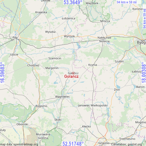
Gołańcz GPS coordinates[2]
52° 56' 35.736" North, 17° 17' 59.82" East
| Map corner | latitude | longitude |
|---|---|---|
| Upper-left | 53.3649°, | 16.59683° |
| Center: | 52.94326°, | 17.29995° |
| Lower-right: | 52.51748°, | 18.00308° |
| Map W x H: | 94.2×94.2 km | = 58.5×58.5mi |
| max Lat: | 54.83135° ⇑17.1% North |
| Gołańcz: | 52.94326° |
| min Lat: | ⇓82.9% South 49.21328° |
| min Long | Gołańcz | max Long |
| 14.20249° | 17.29995° | 24.03723° |
| W 18.6%⇐ | ⇒81.4% E |
Elevation
Elevation of Gołańcz is 95 m = 312 ft, and this is 96.4 m = 316 ft below average elevation for this country.
| Max E: |
974 m = 3196 ft | 82.2% |
| Avg. | 191.4 m = 628 ft | |
| Gołańcz | 95 m = 312 ft | |
Min E: |
-3 m = -10 ft | 17.8% |
See also: Poland elevation on elevation.city.
Geographical zone
Gołańcz is located in North temperate zone (between Tropic of Cancer and the Arctic Circle). Distance of this North polar circle is 1514.4 km =941 mi to North.| Distance of | km | miles | from Gołańcz |
|---|---|---|---|
| North Pole | 4120.3 | 2560.2 | to North |
| Arctic Circle | 1514.4 | 941 | to North |
| Tropic Cancer | 3280.8 | 2038.6 | to South |
| Equator | 5886.7 | 3657.8 | to South |


Nearby cities:
15 places around Gołańcz: (largest is in red/bold)
• Białośliwie
21.4 km =13.3 mi,  326°
326°
• Budzyń
21.7 km =13.5 mi,  254°
254°
• Chodzież
26.1 km =16.2 mi,  282°
282°
• Damasławek
17.7 km =11 mi,  130°
130°
• Janowiec Wielkopolski
24.4 km =15.2 mi,  148°
148°
• Kcynia
13.7 km =8.5 mi,  66°
66°
• Królikowo
21.8 km =13.5 mi,  85°
85°
• Margonin
14.2 km =8.8 mi, 283°
• Mieścisko
22.3 km =13.9 mi,  174°
174°
• Osiek nad Notecią
19.7 km =12.2 mi,  358°
358°
• Sadki
26.1 km =16.2 mi,  22°
22°
• Szamocin
14.9 km =9.3 mi,  309°
309°
• Wapno
12.4 km =7.7 mi,  108°
108°
• Wyrzysk
23.4 km =14.5 mi,  354°
354°
• Wągrowiec
16.4 km =10.2 mi,  204°
204°
Sources, notices
• [Note1] Compared only with cities in Poland existing in our database
• [Src1] Map data: © OpenStreetMap contributors (CC-BY-SA)
• [Src2] Other city data from geonames.org with taken over terms of usage.
• [Src3] Geographical zone / Annual Mean Temperature by Robert A. Rohde @ Wikipedia
