Wyrzysk geodata
Wyrzysk (Greater Poland) is a seat of a third-order administrative division; located in Poland in Europe/Warsaw (GMT+2) time zone. With population of 5,263 people, there are 659 cities with bigger population in this country. Compared to other cities in Poland, 85.8% of cities are located further ↓South; 81.7% of cities are located further →East and 91.6% of cities have higher elevation than Wyrzysk. Note1


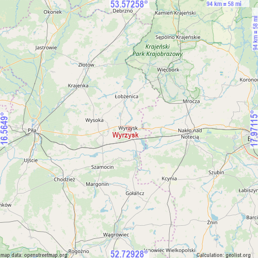
Wyrzysk GPS coordinates[2]
53° 9' 10.8" North, 17° 16' 4.872" East
| Map corner | latitude | longitude |
|---|---|---|
| Upper-left | 53.57258°, | 16.5649° |
| Center: | 53.153°, | 17.26802° |
| Lower-right: | 52.72928°, | 17.97115° |
| Map W x H: | 93.8×93.8 km | = 58.3×58.3mi |
| max Lat: | 54.83135° ⇑14.2% North |
| Wyrzysk: | 53.153° |
| min Lat: | ⇓85.8% South 49.21328° |
| min Long | Wyrzysk | max Long |
| 14.20249° | 17.26802° | 24.03723° |
| W 18.3%⇐ | ⇒81.7% E |
Elevation
Elevation of Wyrzysk is 67 m = 220 ft, and this is 124.4 m = 408 ft below average elevation for this country.
| Max E: |
974 m = 3196 ft | 91.6% |
| Avg. | 191.4 m = 628 ft | |
| Wyrzysk | 67 m = 220 ft | |
Min E: |
-3 m = -10 ft | 8.4% |
See also: Poland elevation on elevation.city.
Geographical zone
Wyrzysk is located in North temperate zone (between Tropic of Cancer and the Arctic Circle). Distance of this North polar circle is 1491.1 km =926.5 mi to North.| Distance of | km | miles | from Wyrzysk |
|---|---|---|---|
| North Pole | 4097 | 2545.8 | to North |
| Arctic Circle | 1491.1 | 926.5 | to North |
| Tropic Cancer | 3304.1 | 2053.1 | to South |
| Equator | 5910.1 | 3672.4 | to South |


Nearby cities:
15 places around Wyrzysk: (largest is in red/bold)
• Białośliwie
10.9 km =6.8 mi,  240°
240°
• Gołańcz
23.4 km =14.5 mi,  174°
174°
• Kcynia
23.2 km =14.4 mi,  140°
140°
• Krajenka
24.5 km =15.2 mi,  311°
311°
• Margonin
23.1 km =14.4 mi,  210°
210°
• Miasteczko Krajeńskie
18.6 km =11.6 mi,  250°
250°
• Mrocza
24.5 km =15.2 mi,  65°
65°
• Nakło nad Notecią
22.3 km =13.9 mi,  93°
93°
• Osiek nad Notecią
3.9 km =2.4 mi,  157°
157°
• Sadki
12.1 km =7.5 mi, 86°
• Sypniewo
24.4 km =15.2 mi,  9°
9°
• Szamocin
16.8 km =10.4 mi, 214°
• Wysoka
12.7 km =7.9 mi,  284°
284°
• Łobżenica
12.2 km =7.6 mi,  356°
356°
• Śmiłowo
23.2 km =14.4 mi,  265°
265°
Sources, notices
• [Note1] Compared only with cities in Poland existing in our database
• [Src1] Map data: © OpenStreetMap contributors (CC-BY-SA)
• [Src2] Other city data from geonames.org with taken over terms of usage.
• [Src3] Geographical zone / Annual Mean Temperature by Robert A. Rohde @ Wikipedia
