Ujście geodata
Ujście (Greater Poland) is a seat of a third-order administrative division; located in Poland in Europe/Warsaw (GMT+2) time zone. With population of 3,869 people, there are 842 cities with bigger population in this country. Compared to other cities in Poland, 84.3% of cities are located further ↓South; 87.9% of cities are located further →East and 94.1% of cities have higher elevation than Ujście. Note1


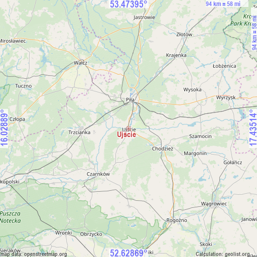
Ujście GPS coordinates[2]
53° 3' 12.204" North, 16° 43' 55.236" East
| Map corner | latitude | longitude |
|---|---|---|
| Upper-left | 53.47395°, | 16.02889° |
| Center: | 53.05339°, | 16.73201° |
| Lower-right: | 52.62869°, | 17.43514° |
| Map W x H: | 94×94 km | = 58.4×58.4mi |
| max Lat: | 54.83135° ⇑15.7% North |
| Ujście: | 53.05339° |
| min Lat: | ⇓84.3% South 49.21328° |
| min Long | Ujście | max Long |
| 14.20249° | 16.73201° | 24.03723° |
| W 12.1%⇐ | ⇒87.9% E |
Elevation
Elevation of Ujście is 52 m = 171 ft, and this is 139.4 m = 457 ft below average elevation for this country.
| Max E: |
974 m = 3196 ft | 94.1% |
| Avg. | 191.4 m = 628 ft | |
| Ujście | 52 m = 171 ft | |
Min E: |
-3 m = -10 ft | 5.9% |
See also: Poland elevation on elevation.city.
Geographical zone
Ujście is located in North temperate zone (between Tropic of Cancer and the Arctic Circle). Distance of this North polar circle is 1502.2 km =933.4 mi to North.| Distance of | km | miles | from Ujście |
|---|---|---|---|
| North Pole | 4108.1 | 2552.7 | to North |
| Arctic Circle | 1502.2 | 933.4 | to North |
| Tropic Cancer | 3293.1 | 2046.2 | to South |
| Equator | 5899 | 3665.5 | to South |


Nearby cities:
15 places around Ujście: (largest is in red/bold)
• Białośliwie
26.9 km =16.7 mi,  77°
77°
• Budzyń
25 km =15.5 mi,  136°
136°
• Chodzież
14.1 km =8.8 mi,  117°
117°
• Czarnków
20.2 km =12.6 mi,  213°
213°
• Kaczory
11.4 km =7.1 mi,  60°
60°
• Lubasz
26.4 km =16.4 mi, 211°
• Margonin
25.8 km =16 mi,  110°
110°
• Miasteczko Krajeńskie
18.9 km =11.7 mi,  74°
74°
• Piła
10.9 km =6.8 mi,  2°
2°
• Siedlisko
24.3 km =15.1 mi,  252°
252°
• Skrzatusz
19.5 km =12.1 mi,  329°
329°
• Szamocin
26.5 km =16.5 mi,  96°
96°
• Szydłowo
14.5 km =9 mi, 326°
• Trzcianka
18.5 km =11.5 mi,  265°
265°
• Śmiłowo
15.6 km =9.7 mi,  53°
53°
Sources, notices
• [Note1] Compared only with cities in Poland existing in our database
• [Src1] Map data: © OpenStreetMap contributors (CC-BY-SA)
• [Src2] Other city data from geonames.org with taken over terms of usage.
• [Src3] Geographical zone / Annual Mean Temperature by Robert A. Rohde @ Wikipedia
