Chodzież geodata
Chodzież (Greater Poland) is a seat of a third-order administrative division; located in Poland in Europe/Warsaw (GMT+2) time zone. With population of 19,776 people, there are 244 cities with bigger population in this country. Compared to other cities in Poland, 83.5% of cities are located further ↓South; 85.8% of cities are located further →East and 92.5% of cities have higher elevation than Chodzież. Note1


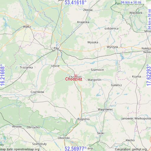
Chodzież GPS coordinates[2]
52° 59' 42.18" North, 16° 55' 11.28" East
| Map corner | latitude | longitude |
|---|---|---|
| Upper-left | 53.41618°, | 16.21668° |
| Center: | 52.99505°, | 16.9198° |
| Lower-right: | 52.56977°, | 17.62293° |
| Map W x H: | 94.1×94.1 km | = 58.5×58.5mi |
| max Lat: | 54.83135° ⇑16.5% North |
| Chodzież: | 52.99505° |
| min Lat: | ⇓83.5% South 49.21328° |
| min Long | Chodzież | max Long |
| 14.20249° | 16.9198° | 24.03723° |
| W 14.2%⇐ | ⇒85.8% E |
Elevation
Elevation of Chodzież is 62 m = 203 ft, and this is 129.4 m = 425 ft below average elevation for this country.
| Max E: |
974 m = 3196 ft | 92.5% |
| Avg. | 191.4 m = 628 ft | |
| Chodzież | 62 m = 203 ft | |
Min E: |
-3 m = -10 ft | 7.5% |
See also: Poland elevation on elevation.city.
Geographical zone
Chodzież is located in North temperate zone (between Tropic of Cancer and the Arctic Circle). Distance of this North polar circle is 1508.7 km =937.5 mi to North.| Distance of | km | miles | from Chodzież |
|---|---|---|---|
| North Pole | 4114.6 | 2556.7 | to North |
| Arctic Circle | 1508.7 | 937.5 | to North |
| Tropic Cancer | 3286.6 | 2042.2 | to South |
| Equator | 5892.5 | 3661.4 | to South |


Nearby cities:
15 places around Chodzież: (largest is in red/bold)
• Białośliwie
18.4 km =11.4 mi,  48°
48°
• Budzyń
12.6 km =7.8 mi,  158°
158°
• Czarnków
26 km =16.2 mi,  246°
246°
• Gołańcz
26.1 km =16.2 mi,  102°
102°
• Kaczory
12.3 km =7.6 mi,  348°
348°
• Margonin
11.9 km =7.4 mi, 101°
• Miasteczko Krajeńskie
12.8 km =8 mi,  26°
26°
• Piła
21.2 km =13.2 mi,  325°
325°
• Połajewo
25.1 km =15.6 mi,  209°
209°
• Rogoźno
27.4 km =17 mi,  170°
170°
• Ryczywół
21.1 km =13.1 mi,  196°
196°
• Szamocin
14.3 km =8.9 mi,  75°
75°
• Ujście
14.1 km =8.8 mi,  297°
297°
• Wysoka
23.4 km =14.5 mi, 27°
• Śmiłowo
15.7 km =9.8 mi,  0°
0°
Sources, notices
• [Note1] Compared only with cities in Poland existing in our database
• [Src1] Map data: © OpenStreetMap contributors (CC-BY-SA)
• [Src2] Other city data from geonames.org with taken over terms of usage.
• [Src3] Geographical zone / Annual Mean Temperature by Robert A. Rohde @ Wikipedia
