Białośliwie geodata
Białośliwie (Greater Poland) is a seat of a third-order administrative division; located in Poland in Europe/Warsaw (GMT+2) time zone. With population of 2,600 people, there are 1204 cities with bigger population in this country. Compared to other cities in Poland, 85.1% of cities are located further ↓South; 83% of cities are located further →East and 81.2% of cities have higher elevation than Białośliwie. Note1


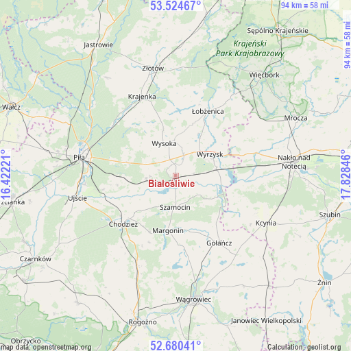
Białośliwie GPS coordinates[2]
53° 6' 16.596" North, 17° 7' 31.188" East
| Map corner | latitude | longitude |
|---|---|---|
| Upper-left | 53.52467°, | 16.42221° |
| Center: | 53.10461°, | 17.12533° |
| Lower-right: | 52.68041°, | 17.82846° |
| Map W x H: | 93.9×93.9 km | = 58.3×58.3mi |
| max Lat: | 54.83135° ⇑14.9% North |
| Białośliwie: | 53.10461° |
| min Lat: | ⇓85.1% South 49.21328° |
| min Long | Białośliwie | max Long |
| 14.20249° | 17.12533° | 24.03723° |
| W 17%⇐ | ⇒83% E |
Elevation
Elevation of Białośliwie is 97 m = 318 ft, and this is 94.4 m = 310 ft below average elevation for this country.
| Max E: |
974 m = 3196 ft | 81.2% |
| Avg. | 191.4 m = 628 ft | |
| Białośliwie | 97 m = 318 ft | |
Min E: |
-3 m = -10 ft | 18.8% |
See also: Poland elevation on elevation.city.
Geographical zone
Białośliwie is located in North temperate zone (between Tropic of Cancer and the Arctic Circle). Distance of this North polar circle is 1496.5 km =929.9 mi to North.| Distance of | km | miles | from Białośliwie |
|---|---|---|---|
| North Pole | 4102.4 | 2549.1 | to North |
| Arctic Circle | 1496.5 | 929.9 | to North |
| Tropic Cancer | 3298.8 | 2049.8 | to South |
| Equator | 5904.7 | 3669 | to South |


Nearby cities:
15 places around Białośliwie: (largest is in red/bold)
• Budzyń
25.6 km =15.9 mi,  201°
201°
• Chodzież
18.4 km =11.4 mi,  228°
228°
• Gołańcz
21.4 km =13.3 mi,  146°
146°
• Kaczory
16.3 km =10.1 mi,  269°
269°
• Krajenka
23.3 km =14.5 mi,  337°
337°
• Margonin
14.7 km =9.1 mi,  188°
188°
• Miasteczko Krajeńskie
8.1 km =5 mi,  264°
264°
• Osiek nad Notecią
11.2 km =7 mi,  81°
81°
• Piła
26.4 km =16.4 mi,  281°
281°
• Sadki
22.5 km =14 mi,  73°
73°
• Szamocin
8.5 km =5.3 mi,  179°
179°
• Wyrzysk
10.9 km =6.8 mi,  60°
60°
• Wysoka
8.9 km =5.5 mi, 341°
• Łobżenica
19.6 km =12.2 mi,  26°
26°
• Śmiłowo
14.1 km =8.8 mi, 284°
Sources, notices
• [Note1] Compared only with cities in Poland existing in our database
• [Src1] Map data: © OpenStreetMap contributors (CC-BY-SA)
• [Src2] Other city data from geonames.org with taken over terms of usage.
• [Src3] Geographical zone / Annual Mean Temperature by Robert A. Rohde @ Wikipedia
