Lichnowy geodata
Lichnowy (Pomerania) is a populated place; located in Poland in Europe/Warsaw (GMT+2) time zone. With population of 973 people, there are 2547 cities with bigger population in this country. Compared to other cities in Poland, 95.4% of cities are located further ↓South; 61.7% of cities are located further →East and 98.8% of cities have higher elevation than Lichnowy. Note1


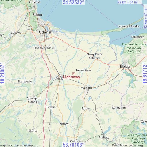
Lichnowy GPS coordinates[2]
54° 6' 54.792" North, 18° 54' 50.364" East
| Map corner | latitude | longitude |
|---|---|---|
| Upper-left | 54.52532°, | 18.21087° |
| Center: | 54.11522°, | 18.91399° |
| Lower-right: | 53.70103°, | 19.61712° |
| Map W x H: | 91.7×91.7 km | = 57×57mi |
| max Lat: | 54.83135° ⇑4.6% North |
| Lichnowy: | 54.11522° |
| min Lat: | ⇓95.4% South 49.21328° |
| min Long | Lichnowy | max Long |
| 14.20249° | 18.91399° | 24.03723° |
| W 38.3%⇐ | ⇒61.7% E |
Elevation
Elevation of Lichnowy is 6 m = 20 ft, and this is 185.4 m = 608 ft below average elevation for this country.
| Max E: |
974 m = 3196 ft | 98.8% |
| Avg. | 191.4 m = 628 ft | |
| Lichnowy | 6 m = 20 ft | |
Min E: |
-3 m = -10 ft | 1.2% |
See also: Poland elevation on elevation.city.
Geographical zone
Lichnowy is located in North temperate zone (between Tropic of Cancer and the Arctic Circle). Distance of this North polar circle is 1384.1 km =860 mi to North.| Distance of | km | miles | from Lichnowy |
|---|---|---|---|
| North Pole | 3990 | 2479.3 | to North |
| Arctic Circle | 1384.1 | 860 | to North |
| Tropic Cancer | 3411.1 | 2119.6 | to South |
| Equator | 6017 | 3738.8 | to South |


Nearby cities:
15 places around Lichnowy: (largest is in red/bold)
• Cedry Wielkie
15.3 km =9.5 mi,  343°
343°
• Czarlin
12.2 km =7.6 mi,  234°
234°
• Drewnica
19.4 km =12.1 mi,  8°
8°
• Kmiecin
17.3 km =10.7 mi,  61°
61°
• Lisewo Malborskie
5.9 km =3.7 mi,  249°
249°
• Lubieszewo
11.6 km =7.2 mi,  43°
43°
• Malbork
11.5 km =7.1 mi,  140°
140°
• Miłoradz
11.3 km =7 mi,  178°
178°
• Nowy Dwór Gdański
17.2 km =10.7 mi,  50°
50°
• Nowy Staw
6.6 km =4.1 mi,  69°
69°
• Ostaszewo
11.1 km =6.9 mi, 12°
• Pszczółki
15.5 km =9.6 mi,  294°
294°
• Subkowy
15.7 km =9.8 mi,  216°
216°
• Suchy Dąb
14.1 km =8.8 mi,  317°
317°
• Tczew
9.2 km =5.7 mi, 254°
Sources, notices
• [Note1] Compared only with cities in Poland existing in our database
• [Src1] Map data: © OpenStreetMap contributors (CC-BY-SA)
• [Src2] Other city data from geonames.org with taken over terms of usage.
• [Src3] Geographical zone / Annual Mean Temperature by Robert A. Rohde @ Wikipedia
