Tczew geodata
Tczew (Pomerania) is a seat of a second-order administrative division; located in Poland in Europe/Warsaw (GMT+2) time zone. With population of 60,133 people, there are 86 cities with bigger population in this country. Compared to other cities in Poland, 95.1% of cities are located further ↓South; 63.8% of cities are located further →East and 96.3% of cities have higher elevation than Tczew. Note1


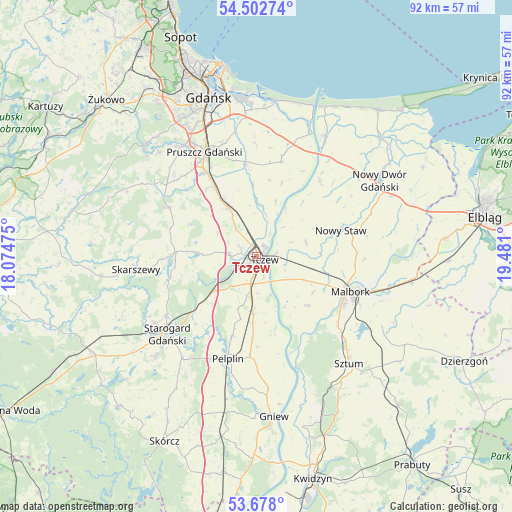
Tczew GPS coordinates[2]
54° 5' 32.712" North, 18° 46' 40.332" East
| Map corner | latitude | longitude |
|---|---|---|
| Upper-left | 54.50274°, | 18.07475° |
| Center: | 54.09242°, | 18.77787° |
| Lower-right: | 53.678°, | 19.481° |
| Map W x H: | 91.7×91.7 km | = 57×57mi |
| max Lat: | 54.83135° ⇑4.9% North |
| Tczew: | 54.09242° |
| min Lat: | ⇓95.1% South 49.21328° |
| min Long | Tczew | max Long |
| 14.20249° | 18.77787° | 24.03723° |
| W 36.2%⇐ | ⇒63.8% E |
Elevation
Elevation of Tczew is 29 m = 95 ft, and this is 162.4 m = 533 ft below average elevation for this country.
| Max E: |
974 m = 3196 ft | 96.3% |
| Avg. | 191.4 m = 628 ft | |
| Tczew | 29 m = 95 ft | |
Min E: |
-3 m = -10 ft | 3.7% |
See also: Tczew elevation on elevation.city.
Geographical zone
Tczew is located in North temperate zone (between Tropic of Cancer and the Arctic Circle). Distance of this North polar circle is 1386.7 km =861.7 mi to North.| Distance of | km | miles | from Tczew |
|---|---|---|---|
| North Pole | 3992.5 | 2480.8 | to North |
| Arctic Circle | 1386.7 | 861.7 | to North |
| Tropic Cancer | 3408.6 | 2118 | to South |
| Equator | 6014.5 | 3737.2 | to South |


Nearby cities:
15 places around Tczew: (largest is in red/bold)
• Cedry Wielkie
17.8 km =11.1 mi,  14°
14°
• Cieplewo
17.8 km =11.1 mi,  332°
332°
• Czarlin
4.6 km =2.9 mi,  193°
193°
• Lichnowy
9.2 km =5.7 mi,  74°
74°
• Lisewo Malborskie
3.4 km =2.1 mi,  82°
82°
• Malbork
17.4 km =10.8 mi,  111°
111°
• Miłoradz
12.7 km =7.9 mi,  133°
133°
• Nowy Staw
15.8 km =9.8 mi, 72°
• Ostaszewo
17.5 km =10.9 mi,  40°
40°
• Pszczółki
10.4 km =6.5 mi, 329°
• Subkowy
10 km =6.2 mi,  183°
183°
• Suchy Dąb
12.9 km =8 mi,  356°
356°
• Trąbki Wielkie
17.8 km =11.1 mi,  299°
299°
• Zduny
13.3 km =8.3 mi,  227°
227°
• Łęgowo
17.3 km =10.7 mi, 329°
Sources, notices
• [Note1] Compared only with cities in Poland existing in our database
• [Src1] Map data: © OpenStreetMap contributors (CC-BY-SA)
• [Src2] Other city data from geonames.org with taken over terms of usage.
• [Src3] Geographical zone / Annual Mean Temperature by Robert A. Rohde @ Wikipedia
