Lisewo Malborskie geodata
Lisewo Malborskie (Pomerania) is a populated place; located in Poland in Europe/Warsaw (GMT+2) time zone. With population of 1,280 people, there are 2103 cities with bigger population in this country. Compared to other cities in Poland, 95.3% of cities are located further ↓South; 62.9% of cities are located further →East and 98.9% of cities have higher elevation than Lisewo Malborskie. Note1


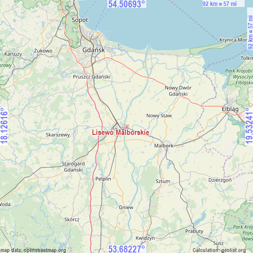
Lisewo Malborskie GPS coordinates[2]
54° 5' 47.94" North, 18° 49' 45.408" East
| Map corner | latitude | longitude |
|---|---|---|
| Upper-left | 54.50693°, | 18.12616° |
| Center: | 54.09665°, | 18.82928° |
| Lower-right: | 53.68227°, | 19.53241° |
| Map W x H: | 91.7×91.7 km | = 57×57mi |
| max Lat: | 54.83135° ⇑4.7% North |
| Lisewo Malborskie: | 54.09665° |
| min Lat: | ⇓95.3% South 49.21328° |
| min Long | Lisewo Malborsk | max Long |
| 14.20249° | 18.82928° | 24.03723° |
| W 37.1%⇐ | ⇒62.9% E |
Elevation
Elevation of Lisewo Malborskie is 5 m = 16 ft, and this is 186.4 m = 612 ft below average elevation for this country.
| Max E: |
974 m = 3196 ft | 98.9% |
| Avg. | 191.4 m = 628 ft | |
| Lisewo Malborskie | 5 m = 16 ft | |
Min E: |
-3 m = -10 ft | 1.1% |
See also: Poland elevation on elevation.city.
Geographical zone
Lisewo Malborskie is located in North temperate zone (between Tropic of Cancer and the Arctic Circle). Distance of this North polar circle is 1386.2 km =861.3 mi to North.| Distance of | km | miles | from Lisewo Malborskie |
|---|---|---|---|
| North Pole | 3992.1 | 2480.6 | to North |
| Arctic Circle | 1386.2 | 861.3 | to North |
| Tropic Cancer | 3409.1 | 2118.3 | to South |
| Equator | 6015 | 3737.5 | to South |


Nearby cities:
15 places around Lisewo Malborskie: (largest is in red/bold)
• Cedry Wielkie
16.8 km =10.4 mi,  3°
3°
• Cieplewo
19.1 km =11.9 mi,  323°
323°
• Czarlin
6.6 km =4.1 mi,  221°
221°
• Lichnowy
5.9 km =3.7 mi,  69°
69°
• Lubieszewo
17.1 km =10.6 mi,  52°
52°
• Malbork
14.5 km =9 mi,  117°
117°
• Miłoradz
10.9 km =6.8 mi,  147°
147°
• Nowy Staw
12.5 km =7.8 mi, 69°
• Ostaszewo
15.1 km =9.4 mi,  31°
31°
• Pszczółki
12.1 km =7.5 mi,  314°
314°
• Subkowy
11.2 km =7 mi,  200°
200°
• Suchy Dąb
13 km =8.1 mi,  341°
341°
• Tczew
3.4 km =2.1 mi,  262°
262°
• Zduny
16.3 km =10.1 mi,  234°
234°
• Łęgowo
18.9 km =11.7 mi, 319°
Sources, notices
• [Note1] Compared only with cities in Poland existing in our database
• [Src1] Map data: © OpenStreetMap contributors (CC-BY-SA)
• [Src2] Other city data from geonames.org with taken over terms of usage.
• [Src3] Geographical zone / Annual Mean Temperature by Robert A. Rohde @ Wikipedia
