Ostaszewo geodata
Ostaszewo (Pomerania) is a populated place; located in Poland in Europe/Warsaw (GMT+2) time zone. With population of 1,017 people, there are 2435 cities with bigger population in this country. Compared to other cities in Poland, 96.5% of cities are located further ↓South; 60.8% of cities are located further →East and 99.3% of cities have higher elevation than Ostaszewo. Note1


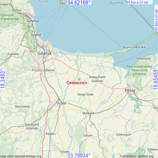
Ostaszewo GPS coordinates[2]
54° 12' 45.216" North, 18° 57' 5.112" East
| Map corner | latitude | longitude |
|---|---|---|
| Upper-left | 54.62169°, | 18.2483° |
| Center: | 54.21256°, | 18.95142° |
| Lower-right: | 53.79934°, | 19.65455° |
| Map W x H: | 91.4×91.4 km | = 56.8×56.8mi |
| max Lat: | 54.83135° ⇑3.5% North |
| Ostaszewo: | 54.21256° |
| min Lat: | ⇓96.5% South 49.21328° |
| min Long | Ostaszewo | max Long |
| 14.20249° | 18.95142° | 24.03723° |
| W 39.2%⇐ | ⇒60.8% E |
Elevation
Elevation of Ostaszewo is 3 m = 10 ft, and this is 188.4 m = 618 ft below average elevation for this country.
| Max E: |
974 m = 3196 ft | 99.3% |
| Avg. | 191.4 m = 628 ft | |
| Ostaszewo | 3 m = 10 ft | |
Min E: |
-3 m = -10 ft | 0.7% |
See also: Poland elevation on elevation.city.
Geographical zone
Ostaszewo is located in North temperate zone (between Tropic of Cancer and the Arctic Circle). Distance of this North polar circle is 1373.3 km =853.3 mi to North.| Distance of | km | miles | from Ostaszewo |
|---|---|---|---|
| North Pole | 3979.2 | 2472.6 | to North |
| Arctic Circle | 1373.3 | 853.3 | to North |
| Tropic Cancer | 3422 | 2126.3 | to South |
| Equator | 6027.9 | 3745.6 | to South |


Nearby cities:
15 places around Ostaszewo: (largest is in red/bold)
• Cedry Wielkie
7.9 km =4.9 mi,  299°
299°
• Drewnica
8.3 km =5.2 mi,  2°
2°
• Jantar
14.7 km =9.1 mi,  21°
21°
• Kmiecin
13.1 km =8.1 mi,  101°
101°
• Lichnowy
11.1 km =6.9 mi,  192°
192°
• Lisewo Malborskie
15.1 km =9.4 mi,  211°
211°
• Lubieszewo
6.1 km =3.8 mi,  114°
114°
• Mikoszewo
13.5 km =8.4 mi, 4°
• Nowy Dwór Gdański
10.8 km =6.7 mi,  89°
89°
• Nowy Staw
9.3 km =5.8 mi,  156°
156°
• Pszczółki
17.1 km =10.6 mi,  255°
255°
• Stegna
16.5 km =10.3 mi,  39°
39°
• Suchy Dąb
12 km =7.5 mi,  267°
267°
• Tczew
17.5 km =10.9 mi,  220°
220°
• Wiślinka
17 km =10.6 mi,  323°
323°
Sources, notices
• [Note1] Compared only with cities in Poland existing in our database
• [Src1] Map data: © OpenStreetMap contributors (CC-BY-SA)
• [Src2] Other city data from geonames.org with taken over terms of usage.
• [Src3] Geographical zone / Annual Mean Temperature by Robert A. Rohde @ Wikipedia
