Studzionka geodata
Studzionka (Silesia) is a populated place; located in Poland in Europe/Warsaw (GMT+2) time zone. With population of 2,000 people, there are 1469 cities with bigger population in this country. Compared to other cities in Poland, 84.8% of cities are located further ↑North; 63.8% of cities are located further →East and 77.6% of cities have lower elevation than Studzionka. Note1


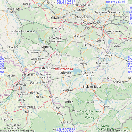
Studzionka GPS coordinates[2]
49° 57' 44.352" North, 18° 46' 22.08" East
| Map corner | latitude | longitude |
|---|---|---|
| Upper-left | 50.41251°, | 18.06968° |
| Center: | 49.96232°, | 18.7728° |
| Lower-right: | 49.50788°, | 19.47593° |
| Map W x H: | 100.6×100.6 km | = 62.5×62.5mi |
| max Lat: | 54.83135° ⇑84.8% North |
| Studzionka: | 49.96232° |
| min Lat: | ⇓15.2% South 49.21328° |
| min Long | Studzionka | max Long |
| 14.20249° | 18.7728° | 24.03723° |
| W 36.2%⇐ | ⇒63.8% E |
Elevation
Elevation of Studzionka is 256 m = 840 ft, and this is 64.6 m = 212 ft above average elevation for this country.
| Max E: |
974 m = 3196 ft | 22.4% |
| Studzionka | 256 m 840 ft | |
| Avg. | 191.4 m = 628 ft | |
Min E: |
-3 m = -10 ft | 77.6% |
See also: Poland elevation on elevation.city.
Geographical zone
Studzionka is located in North temperate zone (between Tropic of Cancer and the Arctic Circle). Distance of this North polar circle is 1845.9 km =1147 mi to North.| Distance of | km | miles | from Studzionka |
|---|---|---|---|
| North Pole | 4451.8 | 2766.2 | to North |
| Arctic Circle | 1845.9 | 1147 | to North |
| Tropic Cancer | 2949.4 | 1832.7 | to South |
| Equator | 5555.3 | 3451.9 | to South |


Nearby cities:
15 places around Studzionka: (largest is in red/bold)
• Bąków
8.7 km =5.4 mi,  208°
208°
• Chybie
7.7 km =4.8 mi,  149°
149°
• Drogomyśl
10.4 km =6.5 mi,  186°
186°
• Frelichów
6.5 km =4 mi, 154°
• Kryry
6.5 km =4 mi,  21°
21°
• Krzyżowice
7.6 km =4.7 mi,  289°
289°
• Mnich
8.5 km =5.3 mi,  163°
163°
• Pawłowice
3.9 km =2.4 mi,  268°
268°
• Radostowice
9 km =5.6 mi,  59°
59°
• Rudziczka
8.2 km =5.1 mi,  354°
354°
• Strumień
4.6 km =2.9 mi, 185°
• Suszec
7.6 km =4.7 mi,  10°
10°
• Zaborze
10.2 km =6.3 mi,  167°
167°
• Zabłocie
6.6 km =4.1 mi, 174°
• Zbytków
5.5 km =3.4 mi,  216°
216°
Sources, notices
• [Note1] Compared only with cities in Poland existing in our database
• [Src1] Map data: © OpenStreetMap contributors (CC-BY-SA)
• [Src2] Other city data from geonames.org with taken over terms of usage.
• [Src3] Geographical zone / Annual Mean Temperature by Robert A. Rohde @ Wikipedia
